Now and again, we check out what's being offered up for sale by the Office for Real Property Utilization and Disposal. It's mostly to rekindle our childhood fantasies of living in a lighthouse — our own hermitage in an eternally fog-blanketed solitary garden. In the past, we had fixated on this quaint Second Empire sea cottage and this oil platform with micronational ambitions. There always seems to be a couple for sale, perhaps because more modern, GPS-augmented maritime navigation systems have created redundancies. And indeed there are four retired lighthouses on the auction block at the moment, or soon will be: allaredefinitebeauties.
The island and everything on it is up for sale. That includes buildings that once housed or currently store the pathogens responsible for foot-and-mouth disease, hog cholera, African swine fever and various others that invariable delight fantasists, conspiracy theorists and apocalypse aficionados. To ensure easy access for the new owners, marine ferries will also be included in the sale.
We've always hoped that the government would donate the research facilities, or lease them for $1/year, to Richard Pell so that he can house and expand his PostNatural History Museum.
Because there's been quite a lot of talk about the possibility of traffic disruption on the Suez Canal caused by the civil unrest in Egypt, we read up on the history of the waterway, primarily using Wikipedia, of course. In the process, we again stumbled upon the so-called Yellow Fleet, a group of 14 international vessels trapped in the canal during the Six-Day War of 1967.
After the short-lived war ended, the ships were still unable to pass through, as the canal remained closed. All ships were forced to anchor together in the Great Bitter Lake, and there they remained until the waterway was re-opened in 1975 — 8 years later!
Of course, the crews weren't trapped there during all those years, left there to fend for themselves on the border between belligerent countries. Some were allowed to go home, and relief crews were brought in. But the ships always had a crew to maintain them.
To pass the time, the fleet organized group entertainments and activities, such as card games, movie nights, football tournaments and water skiing. According to a website by Bjoern Moritz devoted to martime stamps, a year into their captivity in October 1968, the fleet organized “the ‘Bitter Lake Olympics’, coinciding with the Olympic Games in Mexico City. Crews from eight nations competed in 14 disciplines, among them fishing, sailing, acrobatic jumping and soccer. Hand crafted medals were the awards. Life boats became equipped with sailing gear, and a ‘Yacht Club’ was founded.”
We're a little disappointed not to hear of some gardening that might have gone on — of defiant gardens cultivated not for food necessarily but as a place of respite in the middle of the war and the desert.
One other activity the men on board did was making stamps by hand. Now much sought after by collectors, they weren't actual stamps. Moritz refers to them as “labels,” explaining that “[r]eal postage had to be added, either Egyptian stamps or meters. Denominations such as ‘pennies’ and ‘cents’, above, shown on some labels, were purely decorative. Yet, some covers are known to have reached their recipients ‘franked’ with the locals alone.”
Surely in a parallel world Suez Canal, the Egyptian postal service simply allowed all mails from the fleet to go through with only the homemade stamps. “Surely a few envelops aren't going to bankrupt the system,” they reasoned.
The fleet having been vested with one of the attributes of sovereignty, the captain of the Swedish ship MS Nippon, a Kurtz-like figure turned mad by the omnipresent sand — by that grit in his mouth that he wakes up to every morning, those granular bullets that constantly blitzed his eyes, that coarseness in his crotch, the protective keffiyeh he wears but overheats his polar blood, was then inspired to declare his vessel sovereign territory. Other captains followed his lead, their mental healths, too, having deteriorated not long ago. An archipelago of micronations was thus born.
The spring of 1975 came and went, but the canal remained closed. Another 8 years would pass before traffic was able to go through again, long after the owners of the ships had abandoned their costly efforts to repossess them. During that time, the President-Captains further consolidated their rule. Both Egypt and Israel were too busy with other matters to pay attention, but in the Camp David Accords, the two countries finally recognized their sovereignty.
Flash forwarded to the present through the ensuing decades of relatively prosperity fueled by boutique stamp production and Lonely Planet-toting trekkers, and there's another crisis. (For in this parallel world, conflict is also a constant.) Another Suez Canal blockade, another fleet trapped, another Bitter Lake Olympics. And more captains going unhinged from a decade of isolation, then more micronations. In another Camp David powwow, the major powers insist that Egypt cede control of the canal to the League of Suez Canal Micronations to ensure that no future conflict will again disrupt the flow of trade.
Glacier/Island/Storm Week may have come and gone, but it needn't have ended with the last post. The bewilderingly knotting series of posts could be continually spliced with more projects and more commentaries. There's no reason why everyday can't be Glacier/Island/Storm Day. In fact, this sort of multi-blog symposium needn't augment just Geoff Manaugh's curriculum at Columbia, as one could dispatch an artificial glacier or a replicant island or Zeus aerosolized into a horny cloud to infiltrate other studios of other departments of other schools.
With that said, here then is Sea Change, or impending dune, Kristin Schuster's marvelous proposal for a beach access infrastructure on Galveston Island, Texas.
Completed in 2003 as her master thesis project at Rice University's School of Architecture, Sea Change was later published in the 7th issue, titled Landscape within Architecture, of the then twice yearly journal, now annual book 306090.
Rather than summarize the project with cursory commentary and strategic blockquoting, Schuster's article, with the kind permission of the publishers and editors of 306090, will be reprinted here in nearly its entirety. This is our ur-beach; no way were we going to hack it into pieces. It's probably hard to get a copy anyway, as the issue is out of print and sells for over $100 on Amazon, save one.
But before we get to Schuster's piece, it's worth prefacing it with a blockquote from guest editor David L. Hay's introductory essay.
For much of the twentieth century, architects were trained to conceive and represent their work as if in isolation. In keeping with the priorities of high modernism, context was acknowledged only in terms of formal and material aspects, primarily as apprehended through vision. When the structured illusions of modernism began to come undone, however, apprehensions about buildings as static and isolated objects quickly emerged in architectural theory and criticism. The qualities of stability and clarity long valued as attributes of monumentality became suspect because of their association with interpretive closure. In other words, the insufficiency of buildings as objects was attributed, in part, to their pretense to the contrary. As shaping influences, rigid ideals of form, structure, and type were abandoned in favor of dynamic conditions, forces, and flows. “Performance” in architecture, long identified with resistance to formal and programmatic change, is now associated with responsiveness, flexibility, and adaptability, on the model of navigation. In theory and criticism, the ideal resistance to interpretation has given rise to an orthodoxy of inconclusiveness in which ambiguity, subtlety, and suppleness are highly prize.
Now on to Sea Change.
Siting the Disaster
As a heavily developed coastal barrier island, Galveston is plagued by disasters. There is the sudden disaster—the intermittent bombardment of the island by tropical storms and hurricanes—and there is the slow disaster—the alarming rate at which the island’s beaches are eroding. Shoreline erosion and storm damage are treated as separate disasters, even though their effects are linked: the beaches and dunes are the island’s natural defenses against storm effects.
Once the economic capital of the Texas Gulf Coast, the City of Galveston is now a struggling tourist town. Potential in the form of property tax revenue from as yet undeveloped land and increased visitor traffic are bringing local government to push for development of nearly all of the remaining open land on the island in the form of second home development on the island’s West End. Although this means increased revenue for the city and county, the foundation of this economy is federal money in the form of subsidized insurance and disaster mitigation funds. These subsidies support high values for the private property that is threatened by the natural events that shape the land. In response, erosion and storms are met with resistive counter-measures that protect private property on the island at the further financial expense of county and federal taxpayers as well as the physical expense of the coastal environment.
Traditional protective measures such as the eleven-mile-long Galveston Seawall have been deemed too costly to build and maintain. Geotextile tubes are the latest technology employed to battle flooding and the creeping property line. Intended to replace eroded dunes and protect the hinterland by not allowing the shoreline to move landward, these resistive measures redirect the forces further down the island, causing increased erosion and beach loss in front of other unprotected property. While Geotubes are often billed as beach protection, they function as private property protection. Because sand continues to wash away while the stabilized shoreline ceases to move back, the beach disappears completely in front of these structures. As wave energy is not absorbed by these structures, the unprotected property adjacent to them will erode at an increased rate.
As a result of this process, the Texas General Land Office has designated West Galveston Island, the twenty-one miles of island down-stream of the seawall, a critical erosion area. Due to the channelization of the Mississippi River, which diverted up-stream sand sources, and the development of the Houston Ship channel, sand migration on Galveston Island functions at a deficit of 700,000 cubic yards each year. At the Western end of the seawall, the beach erosion rate is in excess of fifteen feet per year.
To counter this, beaches are currently rebuilt along Galveston’s shore through a process called beach nourishment. This is the process of replacing the sand that migrates off of Galveston beaches each year. Not a permanent solution, beach nourishment must be repeated periodically as sand continues to be lost. This process relies on the availability of compatible sand supplies, which are increasingly rare.
Mind you, the very property that is disappearing is that which sells for $850 per linear foot of beachfront and generates $34,000,000 in property tax revenue each year. This explains why of the twelve factors considered in the determination of a critical erosion area designation, private and personal loss is considered the most important while public access is third, public safety is eleventh, and human activity ranks as the least important factor taken into consideration. Ironically, the beaches that are sacrificed by these property protection strategies are the foundation of the tourism economy.
That private losses currently rank more critically than public access, safety, and human activity is particularly significant considering the historical political relationship between Texans and their beaches. Texas is unusual in that beaches are public (state) property. In 1977 the Texas Open Beaches Act (TOBA) legally established that “the area extending from the line of mean low tide of the Gulf of Mexico to the line of vegetation bordering on the Gulf of Mexico” is public beach. The main focus of the TOBA is to establish unrestricted access by the public to any publicly owned beach, primarily by disallowing construction that blocks access to the beach. While it seems completely unexceptional that private construction not be allowed on public land, the unstable nature of the shoreline in conjunction with the particular legal definition of the public property boundary set up by the TOBA creates a condition of perpetual conflict and struggle between private property rights and public access. The property line is always moving. Buildings that cross the boundary and become partially or fully on public land must be removed. From the perspective of the private property owner, the natural formal cycle of the island is a disaster.
The disaster that plagues Galveston Island is the collision between private property rights and public access to public land. The disaster is the economic collision between the forces that have shaped the island and Gulf Coast over thousands of years, and the people who don’t recognize them and thus claim ownership of the land. The disaster is not that the shoreline moves- the disaster is the fact that it is expected not to. The disaster is the perception of the land.
Drawing the Line
This perception is based on traditional models of barrier island formation, which conceptualize the island on a macroscopic scale as a cohesive mass of drifting sand—a kind of solid, if mobile, landmass. The trouble with these timeless abstractions is that they allow us to consider the island in way that causes our structures to be physically incompatible with the landscape. This incompatibility becomes most obvious at moments of disastrous structural failure as houses collapse into the sea after sand is eroded around their foundations. It can also be seen in the struggle for beach maintenance by property rights groups, as technologies based on these models are even further incapable of addressing the ambiguity between public and private. The tools and technologies currently used to design and construct in these environments treat them as fixed topography, as does the legal definition of the land. The primary assertion of the Texas Open Beaches Act establishes a line that is not a line at all. A new concept of the island is required, one based on an understanding of the island as an environment of forces. Such a conception requires new ways of building on the island and understanding what it means to do so. This understanding could lead to economically sustainable tourism-based modes of human activity and presence that directly confront notions of private property rights as currently practiced on Galveston Island. The first step is to engage the processes, and rectify the social relationship with them.
Modeling the Site
This project defines the island as a slurry—a semi-liquid mixture of sand and water in different ratios—rather than as a drifting mass of sand. There is no delineable distinction between the island and the body of water surrounding it, nor between the public beach and private hinterland. The lines of mean low tide and vegetation are ill-conceived as lines. This understanding of the island site gives credibility to the tidal, wave, wind, current, and submergence forces that have been identified as active in island formation by recognizing that they are perpetually active. They are not separate from or located outside the island, but material conditions of difference within it.
The tools and technologies exist to work within this concept. Whereas a topography map renders the site solid, passive, and receptive, a vector drawing models a slurry that is ‘alive’ with actively willful behaviors. By drawing the site as flow and form rather than topographic configuration, vector drawing allows the design to be based on the relationships present within the site which remain constant even as the configuration changes. In dealing with an unfixed site, designing for the relationships rather than the configuration ensures the relevance of the intervention beyond the dissolution of the current configuration.
[The opening image plus the two above] reveal the complex relationship between the weather and the landscape as they are traditionally conceptualized. Each is an iteration built on the previous, a rendering of the forces and forms present at the site over one calendar year. More importantly, these drawings provide formal and operational implications for the proposed system of beach access, as well as the foundation for a three-dimensional cad drawing process to test and represent the final design proposal for beach access.
To recognize that the landscape is active gives new imperative to the act of intervening. To intervene in such a site is to harness the activity of the site, redirecting the energy of the slurry to effect the desired change indirectly. The landscape will do the work. The intervention must remain viable in the kinetic environment, and it must be flexible enough to ride with the slurry. In other words, it will function at the level of the relationships within the slurry, and the relationship between the slurry and humans.
Meshes are the ideal structures in such an environment, having both structure and flexibility. A mesh with inherent structural properties, such as a pleated textile, will support the functional interests of human activity while strategically mediating the behavior of the slurry. The flexibility of such a mesh is limited by the size of the pleats and their orientation in relationship to overall size of the piece of material. Thus, for the scale of application relative to the scale of the pleats necessary to give the given material structure, a panel size can be determined. The use of a panel system allows for added flexibility in the deformations, and strategically controlling connections between panels and layering of different material types can add greater sensitivity to specific conditions of the slurry.
Blurring the Line
The proposed beach access infrastructure takes the form of a system of geotextile panels in order to take advantage of the natural abilities of a mesh to strategically mediate the behavior of both people and a slurry. There are three panel types, each of which corresponds to different conditions within the slurry. Each panel corresponds to a zone of the site, and is able to mediate the slurry and human circulation in the specific ways noted due to construction of the layered section and combination of the materials used. Each panel is anchored in the slurry at only two points, the center of the short edges. As a result, the panel is able to radically deform to accommodate the current configuration of the landscape and the total panel construction in order to remain viable as a system of beach access that is traversable by humans. The combination of unidirectional pleats, spring straps, and a dimensionally stable edge ribbon create specific deformational behaviors that both impact the smoothness of the resulting configuration and add significant sectional characteristics which mediate and channel circulation at another scale. As paths are no longer traversable, new panels must be connected to the system. The result is a constantly configuring system of pathways that operate according to the physical principles of the ecology rather than the territorial logic of human occupation.
The pathways literally blur and stretch the legal boundaries of the site. Physically, the system allows the forces present to be productive of dry beach and dunes as sand is scooped up and channeled inland. Without the system installed, the beach will not exist, having been sacrificed in futile attempts to halt the erasure of the private property inland of it. Without the beach, the island’s $350,000,000 tourism economy would suffer. Politically, the system inverts the current set of priorities which value private property rights over public access to the beach. Due to the physical effects of the intervention, beach access would become a desirable element on private property, whereas now it is often illegally removed or obscured by private property owners wishing to exclude the public from their land and vistas.
Fundamentally, the system makes the workings of the forces within the landscape visible and serves as a marker for the work they can do. Erosion is transformed into a productive process as island change becomes real in the popular concept of the place. By upending the popular conception of the coastal landscape, this project lays a path for dialogue about building technologies and land-use policies more appropriate in a fluid landscape.
For Glacier/Island/Storm Week, we rummaged through our archives for some thematically relevant material. Rather than simply linking to the analogous hashtags (our #ice for #glacier, for instance), we decided to do a bit of curating, ending up with 10 posts per hashtag. We've got nuclear-powered glaciers, a proto-Archigram city in quasi-flight, a pyramid for serving glaciers, ice caps turned space observatories, Thoreau's frozen New England pond reconfigured vertically, avalanche protection structures, an anti-hurricane toy for the rich and famous, vapour cities and more. Go see. #glacier#island#storm
Meanwhile, above is the Morris Island Lighthouse, which has been standing on the same spot on the South Carolina coast since 1867. As the island migrated towards the mainland (as barrier islands wont to do), fans of the lighthouse decided to save the historic structure from certain collapse by armoring its base. The island kept on retreating, and they kept on fortifying. Once it overlooked a wide stretch of beach, but now the lighthouse is itself an island located half a mile out to sea, an immovable geoglobule secreted by its parent island. However, the two islands may yet rejoin, perhaps in the next Ice Age. Or it might attach itself to a different nomadic island just passing by. No doubt that after awhile, it will be secreted once again. Other islands, other shores and other continents will come and go, and the lighthouse will fuse and disentangle with them all, a static marker recording not just the dynamic processes of geomorphology but also the irrational geopolitical mechanics of coastal development and the mercurial aesthetic tastes of those that will (or will not) seek to preserve it for eternity.
If the U.S. Department of Homeland Security leaves its labs on Plum Island — “America's first line of defense against foreign animal diseases” — for swankier digs on the mainland where researchers would be able to handle the most dangerous animal pathogens, what would you do with the abandoned island?
An editor for Nature offered up some suggestions, including using the site for a “future museum on Craig Venter and his synthetic life form” and an “organic plum farm,” of course. But maybe instead of giving it to Craig Venter, the government deeds the buildings and the entire island to Richard Pell for his PostNatural History Museum.
Geoff, Mette and Mark's intensive design studio on Cockatoo Island ended a couple of weeks ago, with the next one in 2011 (or so we hear), so perhaps in the interim they'll island hop to Plum Island next summer (or post-abandonment). How would students respond to this particular island, once described as a “ticking biological time bomb” located so close to so many major population centers? What projects would they confect after rambling about the place where outbreaks of three infectious diseases (for instance, the West Nile virus in 1999) were alleged to have started; where wild animals are killed on sight but a habitat for several bird species is nevertheless supported; and where the serial killer Hannibal Lecter would have enjoyed a brief respite from his incarceration but one which he sneeringly rejected?
Detached physically and conceptually from the everyday and the larger landscapes in so many ways — away from the “mainland” way of doing things and into the avant-garde realms of Dr. Moreau and Dr. No and even into the off-grid DIYs of Giligan's castaway mates and still yet into the seemingly supradimensional fantascapes of Ricardo Montalban and Tattoo: what wildly experimental terrains will they terraform?
On the coast, in a landscape of instabilities and ambiguities, there are surprisingly three things that are constant. Firstly, sea level is rising. Secondly, a huge percentage of the global population live along the coast, a number that's steadily rising. Even if hurricanes after hurricanes after hurricanes kept pummeling their cities of ramshackled hovels, they will not budge. So rather than retreating, they will dig themselves deeper and deeper. And thirdly, they will entrench themselves by basically building walls.
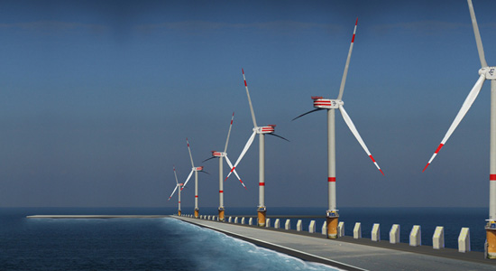
Unlike a similar project further up north, the Tulip Island in the Netherlands, and even the Palms of Dubai, this archipelago will be “based on morphological logic.” Instead of plopping down “arbitrary geometries,” the islands will be “built up from existing banks in the North Sea, using the current morphology to determine their placement.” Instead of isolating themselves, they will be opened up to the dynamic flows of the landscape. They will be “North Sea-specific.”
Once divined out of the sea, these extended coastlines will host natural reserves and sanctuaries for migrating wildlife, windmills and “dune villages.”
Meanwhile, we are of the persuasion that managed retreat is the best of possible solutions to coastal erosion and future inundation by sea level rise. What possible benefits local businesses and the heritage preservation police get from fortifying themselves in concrete are offset by the massive infrastructural cost needed, a multi-decade investment now even more unsustainable in the current financial crisis. And if past projects are anything to go by, what gets built will create more problems than it's supposed to solve.
But we're thinking of the eastern seaboard and the gulf coast of the United States. We don't know much about the coastal geology of Belgium. Sea level rise by climate change may be global, but hyperlocally, it will manifest itself in ways as myriad as the varying geomorphological conditions at every stretch of every coastlines. So maybe this artificial archipelago will work. It's already been conceptualized as anti-Dubai, so it rests on a good footing.
To register once more our fascination with testing grounds, or sites of experimentation and simulations, here is the rack map of concrete slabs at the U.S. Army Corps of Engineers' materials testing facility at Treat Island, Maine.
On the island, material specimens are exposed to natural severe environmental conditions to test for durability. They are subjected to between 100 and 160 freeze-thaw cycles, cyclic inundation of saltwater and air-drying, chloride intrusion, wetting and drying, and abrasion-erosion. There and in many other testing grounds, arranged in museological, Donald Judd-like intervals of solids and negatives, these perfect geometries are coming undone. The building blocks of future cities and monuments fracture and decay in a way that belies their solidity and intended permanence. Bit by bit, atom by atom, structures get nullified and give way.
Stunning news via The Associated Press. Undeterred by the stories of Dubai, the global financial apocalypse, a shaky national political system, the occasional war and sectarian violence, the Beirut-based developer Mohammed Saleh wants to develop “a 3.3-square-kilometre, artificial island shaped like a cedar tree as a major attraction off Lebanon's coast.”
This US$8 billion “paradise” would be aimed primarily at “Lebanese expatriates who have nostalgia for their country and would like to invest in it.” For reasons we can't yet process without experiencing cognitive failure, this marketing strategy will somehow insulate the project from the economic crisis.
In any case, if ever some reclusive billionaire who fantasizes about being the Rockefeller of archi-bloggers and then actually doles out patronage to these outsider spatialists, including us, we would like to use our grotesquely plump fellowship to create a sort of travel guide to the world's artificially terraformed coastlines. In the same illustrative vein as John Briscella's The Urban Gridded Notebook and Work AC's 49 Cities, we'll document with near encyclopedic breadth the fluctuating peripheries of Manhattan, Chicago, Singapore, Dubai, Tokyo and whatever cities that have undergone coastal expansion. San Francisco was once imagined with twin peninsular augments. What other cities were planned to be implanted with geological prosthesis? And what urban (hi)stories can one gleaned from these littoral recontouring?
It will be an antipode history to the future extractive history of sea level rise.
The New York Times paid a visit this week to a national biological defense lab. Scientists there will “do research into some of the nastiest diseases on the planet, among them Ebola, anthrax, tularemia, West Nile virus, drug-resistant tuberculosis, bubonic plague, avian influenza and typhus.”
If that isn't fascinating enough, the lab's “gleaming new building” happens to be located in one of the most unstable types of landform and where hurricanes regularly make a mess of things: the barrier island of Galveston, Texas.
Built atop concrete pylons driven 120 feet into the ground, the seven-floor laboratory was designed to stand up to 140-mile-an-hour winds. Its backup generators and high-security laboratories are 30 feet above sea level.
Says the lab's deputy director, “The entire island can wash away and this is still going to be here.”
A gleaming biological bunker, as impenetrable and monolithic as CIA HQ, a Pandora Box protruding out in a landscape of ruins and shifting sands.
Mapping the Ecotone, Ashley Kelly and Rikako Wakabayashi's winning entry in the design competition Envisioning Gateway, is one of those things that we have been meaning to post for months.
Having earlier attempted to communicate our fascination with coastal interventions and our belief that by merely being sited on such tenuous terrain, they are by default the most interesting type of project there is, we think that the duo's project will be a good postcript to our previous post.
Their proposal is certainly among the best that we have encountered last year, and it definitely deserved its First Prize.
Kelly and Wakabayashi had a two-fold task. First, they had to develop a master plan that unifies the separate units of the Gateway National Recreation Area scattered all over the New York-New Jersey harbor. Second, within this larger scale, they had to design a new park at Floyd Bennet Field in Jamaica Bay, the result of which are seen in the images accompanying this post.
A major element of their proposal is a series of jetties and piers, rigid infrastructure in an otherwise shifting landscape. It's the urban edge intersecting with the natural landscape. From above, they look like the runways of the now defunct airport, here realigned not to direct people off to distant locales but to the site itself.
It's a simple design but a fantastically genius one. It allows park visitors to come “into direct contact with marshlands, tides and fluctuating sea levels” but, in keeping with the natural condition of the park, a place in “necessary flux,” this infrastructure vacillates between accessibility and inaccessibility.
In other words, during low water levels, you can throw around a frisbee or have a picnic or take a hike on dry ground; you can do most anything what you can at a national park or an urban park. But when the waters come and inundate the site, there will certainly be some things that you won't be able to do, although you would now be able to fish from the jetties, do some kayaking and more — until, of course, the site reverts back to drier conditions.
The great deluge may have come but there's no reason to panic. The design being as resilient as it is, the infrastructure hasn't collapsed. The symbiotic relation between the varying ecological and cultural systems hasn't deteriorated.
This is disaster, designed.
There is an important lesson here for coastal cities threatened by sea level rise, especially cities like New Orleans. The prevailing paradigm is to separate urban settlements from the waters, to fortify against attacks from the elements. But it's a catastrophic mistake to think that one can contain something as eternally mutable as the landscape. You cannot freeze the outline of the shores or the riverbanks forever in time and place.
What Kelly and Wakabayashi are saying is open up the city to the waters. Give it a zone of transition — an ecotone — where both land and water can be occupied simultaneously.
In the abstract, replace classical notions of formal clarity and structural stability with an orthodoxy of flexibility and adaptibility.
Meanwhile, it must be mentioned that in addition to being points of access, the jetties and piers are pedagogical tools as well. As the landscape changes around them, they provide a backdrop with which one may be able to discern the various habitats, the disappearance and reemergence of landforms, and fluctuating sea levels.
One may even possibly detect the creeping effects of global warming.
In one of our more recent climate change fantasies, we proposed that the richest and most intensive carbon producing countries should set aside “reservations” in their own territories — and not just in some arid, treeless corner of New Mexico, for instance, but in prime real estate, say, Malibu — for refugees whose Pacific island nations have been swept under the ocean by sea level rise.
Now someone has pointed us to a Wikipedia article on the Nauru Phosphate Corporation, the government entity in charge of phosphate mining in Nauru. Specifically, we were directed to the unfortunately small section about its long-term investments intended to support the citizens once the phosphate reserves have been exhausted.
There, we read that “the Nauru Phosphate Royalties Development group has constructed two of five hi-rise luxury condos in Hawaii, on the island of Oahu. The five towers (two completed as of 10/05) are located on prime Honolulu real estate with ocean views, and represent a benchmark in Honolulu luxury high-rises. Other investments included Nauru House [divested in 2004 to pay off debts] in Melbourne and Hawaiki Tower in Honolulu.”
Should Nauru's co-investors might feel charitable and transfer their shares of these luxury condos to the struggling island, we can imagine these towers, then, being granted extraterritorial status. In spacious floorplans and lushly decorated rooms, Nauru's citizens can ride out the flood in foreign land while still preserving their sovereignty, if not their island culture.
Put in some wind turbines on top, drill a few geothermal pipes into the molten underbelly of Oahu, harness the power of the waves and maybe New Nauru can become a sustainable settlement, something which its most recent incarnation was definitely not. Of course, they may have to battle their neighbors who must protect the market value of their multi-million dollar condos.
Alternatively, they could be employed as migrant service workers by the tennant associations, their wages being sent back home as remittances.
Earlier this month, the president of Kiribati warned the nations of the world that his country will be gone by century's end. Submerged under rising sea level, a casualty of climate change.
And even if, by some ridiculously well-timed miracle, everyone reduces their carbon footprint to near zero, the 92,000 island inhabitants “may be at the point of no return” where reversing the effects of the emissions already in the atmosphere will not come before their atolls get flooded. The president thus asked for help in resettling his people.
While very impolitic, he should demand from the worst polluting nations that as an act of “redemption” they should set aside “reservations” in prime real estate, for instance, some of the Hawaiian islands, where the entire population can collectively forge a new set of geographic identitites instead of being dispersed in diasporic communities around the world.
Maybe China is open to the idea of deleting a part of the Tibetan plateau and exporting the pulverized geology to the Pacific. They will, of course, argue that this a form of carbon emission trading.
Or the European Union could give the president an order or two of Vincent Callebaut's Lilypad.
Quoting Archinect, where we first saw this featured.
LILYPAD is a true amphibian - half aquatic and half terrestrial city - able to accommodate 50,000 inhabitants and inviting the biodiversity to develop its fauna and flora around a central lagoon of soft water collecting and purifying the rain waters. This artificial lagoon is entirely immersed, ballasting the city. It enables inhabitants to live in the heart of the sub aquatic depths. The multi functional program is based on three marinas and three mountains dedicated to work, shopping and entertainment. The whole set is covered by a stratum of planted housing in suspended gardens and crossed by a network of streets and alleyways with organic outline. The goal is to create a harmonious coexistence of humans and nature, exploring new modes of cross-cultural aquatic living.
Kiribati would probably need a less pimped out version, unless, of course, they realign their economy away from fish and phosphate towards eco-tourism — which leads us to wonder: will future climate change refugees become a new caste of service sector workers inhabiting a sort of Floating Hotel & Duty Free Mall, the port of call that comes to you, wherein the fine art of the greeting and linen folding is treated as a Masonic secret passed down from one generation to the next?
In any case, some more unabashedly digital images.
Contrary to popular beliefs, Fresh Kills in New York City's Staten Island doesn't contain the biggest collection of garbage in the world. What Wikipedia says “could be regarded as the largest man-made structure on Earth, with the site's volume [...] exceeding the Great Wall of China” and was once the temporary dump site for the remains of the WTC Towers isn't the largest landfill at all.
In fact, the largest landfill isn't even on land, but rather it is trapped in an oceanic riverine system known as the North Pacific Gyre.
Wikipedia again: “The centre of the North Pacific Gyre is relatively stationary and the circular rotation around it draws waste material in. This has led to the accumulation of flotsam and other debris in huge floating 'clouds' of waste, leading to the informal name The Great Pacific Garbage Patch or Eastern Garbage Patch. While historically this debris has biodegraded, the gyre is now accumulating vast quantities of plastic and marine debris.”
It is so vast, apparently, that these floating clouds have a total area equal to that of 2 Texas.
Which directly leads me to wonder: can you collect these patches to create a floating solid ground?
It'll be like a new Pacific island nation molded together out of “80,000 Nike sneakers and boots” and “tens of thousands of bathtub toys and hockey equipment” lost overboard from cargo ships.
Or a recycled ocean cruisers from where eco-terrorists hunt down polluting holiday cruise ships in the high synthetic seas.
Or better yet, dump it all on the Polynesian archipelago of Tuvalu, which Der Spiegel says is “currently only 10 centimeters above sea level” and “likely to become the first country to succumb entirely to climate change.”
Paradise Lost it may certainly be, but it may yet still be Arcadia Regained from the bottom of the ocean.
Of course, the islanders have the option of not anchoring this newly accumulated stratum of detritus to their former nation; they could submit it to the whims of the ocean currents and trade winds.
And in their intraoceanic meanderings, they'll meet other climate change refugees on their own island nations made out of Barbie dolls. A new trade group could be formed, with the goal of developing self-sufficient economies and expanding their territorial boundaries by mining the Pacific for consumer goods Made in China.
Is this the future site of the New Central Park of the Pacific, designed by Fresh Kills head designer James Corner?
Remember the Sundarbans, that “tapestry of waterways, mudflats, and forested islands at the edge of the Bay of Bengal” and home to an unbelievably huge array of endangered species? The Independentreported last month that one of the inhabited islands there, Lohachara, has “disappeared beneath rising seas.”
“Eight years ago,” we further learn, “the first uninhabited islands - in the Pacific atoll nation of Kiribati - vanished beneath the waves. The people of low-lying islands in Vanuatu, also in the Pacific, have been evacuated as a precaution, but the land still juts above the sea. The disappearance of Lohachara, once home to 10,000 people, is unprecedented.”
So while global warming is uncovering islands elsewhere, it is expected to wipe out about a dozen or so inhabited islands in the Sundarbans in the very near future, resulting in an estimated 70,000 sea level refugees.
The Sundarbans, in other words, couldn't be a more perfect setting for The Army Corps of Engineers: The Game.
As originally and inadequately fantasized here, you as a game player will be given an island, forested or slightly so, but intentionally inhabited so as to give your choices and actions an element of real consequence.
Without intervention, your tropical paradise will be wholly submerged exactly ten years from the start of play. And lest some bothersome Republican Apologist or a second-rate SF novelist obfuscate the science, the data predicting catastrophic sea level rise is irrefutable, its analysis impeccable and unassailable.
Per island is a lone seaside village. You will notice that its plan closely follows the principles of New Urbanism. This is probably because the principal game designers have read too much Nicolai Ouroussoff and consequently have turned homicidal and, like CIA expert waterboarders to a terror suspect, would like nothing more than to see anything that is quaint and earnest placed under simulated drowning and environmental stress, with the possibility of stylistic expiration or total erasure. That or perhaps they have been proselytised by Andrés Duany enough to have developed a raging hero complex for things wholesome and bourgeois.
But whatever.
The waters are coming, and you are tasked to prevent your designated island and its village from sinking.
You will have a budget of $1 trillion, of course, and have all the structures and widgets ever used in the long history of hydroengineering — from the Garden of Eden to the Three Gorges Dam — to choose from: groynes, seawalls, revetments, rip raps, gabions, breakers, levees, dams, canals, bridges, channels, spillways, pumping stations, marram grass, artificial reefs, imported sand and fleets of trailing suction hopper dredgers.
As this is being sponsored by IKEA®, the challenge will be in their assembly.
Since you'll be taking on the role of Chief of Engineers and the rank of lieutenant general, you will command an army of migrant workers from Southeast Asia and the Subcontinent. Choose carefully among the enlisted, since each nationality has been genetically altered to display certain traits.
For instance, the Vietnamese are supremely creative, prone to fits of the imagination. The Thais, meanwhile, are practical and reliable, but there are instances when they get distracted completely. Filipinos are the most collegial and unlikely to disrupt your schedule to air out grievances on their quasi-indentured status. The Laotians are the most hardworking, though sometimes they can be too Western about certain things, namely wages and working conditions. The Indonesians have undertaken the most extensive training, but unfortunately, they lack imagination. The Bangladeshis hate the Indians and vice versa. Everyone dislikes the Pakistanis.
Again, draft wisely, for when the tenth cyclone of the season is on a direct course towards your island, the right mixture of skills and a collaborative team atmosphere will help you weather the flood.
With the grunt work placed on the shoulders and backs of others, you'll have time to strategize. So if you like, you can invite Cornelia Dean and Lieutenant General Carl A. Strock for a candlelight dinner to gather some pointers and maybe even create a cheat sheet. After desert and a fine digestif, you hold a seance to channel Arnold de Ville and Salomon de Caus. Alternatively, everyone gathers around the bonfire on the beach and take turns reciting stories from The Deluge.
You could even organize a weekend charette or a hydrologically-themed lecture (and film) series. For something that's a bit more rigidly curated, you can host an international symposium showcasing the latest hydroengineering research by leaders in the field. Perhaps a design competition can coincide with this event. Countless students and emerging young firms — everyone oozing with talent, vigor, and infectious enthusiasm to make even the most cynical archiblogger weep for joy — will all send in wildly radical yet uncannily practical designs. Of course, your chosen jury will unfortunately have decided long before that they will only going to pick the OMAs and the Hadids and the Schwartzes and the Walkers. They'll laugh; so too will the Pritzker Laureates and the FASLAs. (Unless perhaps you're Rem Koolhaas and decide to throw a fucking hissy fit.)
Or at night, with the impending sea softly breaking against the dunes, you reflect upon the monumental task of lifting Venice above the lagoons for inspiration.
While still clinging on to the pretense that this game is real — and temporarily setting aside the fact that this post wasn't published primarily to point you to The Independent article, but rather to provide a dumping ground for 1) leftover images of TSHDs from this previously mentioned post; 2) some newly collected images of tetrapods; and 3) various links collected last year — here are some prohibitions:
3) You cannot use any part of your budget to embark on a worldwide conservation crusade or to fund research into alternative, non-polluting forms of energy.
4) Your island must remain tectonically stationary, as opposed to airborne.
5) You cannot mechanize your island and install too many A.I. systems that it becomes sentient.
6) It goes without saying that a strategy of managed retreat — arguably the most sensible but, inexplicably, rarely implemented planning approach to future coastal disasters — is not allowed, because that would be too easy.
So if this were indeed a real game, whoever keeps their island with roughly the same pre-game acreage above sea level the longest, wins.
That your construction looks like a Rube Goldberg machine or a psychosis-inducing theatrum machinarum will not count against you. In fact, you might be awarded a Jury Prize.