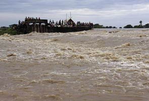
Floods triggered by a huge discharge of water from the Hirakud dam have displaced about 3,800 people and damaged at least 8,000 houses in 14 of Orissa's 30 districts, an official said today.
The state flood control room here said the villagers moved to safer places from low-lying areas of Bargarh, Boudh, Deogarh, Jajpur, Nuapada and Sambalpur districts after water entered their houses.
"They have been provided with emergency food assistance," said a control room official.
Due to heavy rains in the upper catchment areas in the past several days, including in Chhattisgarh, a huge quantity of water is entering the Hirakud reservoir on the river Mahanadi in Sambalpur district, about 350 km from Bhubaneswar.
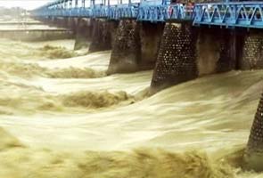
As a result, the dam authorities had to release the excess water by opening 59 of the dam's 64 sluice gates. The inflow of water to the Hirakud Dam was 11.05 cusecs per second and outflow was 9.73 cusecs Friday evening, the official said.
While the released water have already created havoc in several places, more people are likely to face the brunt in the next two days when the water will reach more downstream areas, the official added.
"Flood water up to 13-14 lakh cusecs is apprehended at Munduli in Cuttack district by 3 pm Saturday against pick flood level of 15.82 cusecs recorded in 2008. Floods may take one more day to reach coastal districts," he said.
"So far 1,437 villages of 34 blocks and eight urban local bodies area in 14 districts have been affected by the current floods," he added.
Chief Minister Naveen Patnaik said the government was "closely monitoring" the situation.
"The district administrations are fully geared up to meet any eventualities. Food materials have been stocked in vulnerable places," he told reporters after reviewing the situation at the secretariat.
The government has asked the collectors of all the vulnerable districts located along the Mahanadi river and its tributaries to remain alert and evacuate more people from the low-lying areas if necessary, Special Relief Commissioner P.K. Mohapatra said.
At least 88 people have died and around eight million affected by floods in Pakistan's southern Sindh province and eastern Punjab province, a top official said.
Zafar Iqbal Qadir, chairman of the National Disaster Management Authority (NDMA), said that most of the people who lost their homes in Sindh and Punjab have been provided accommodation at different relief camps set up by the government.
Food and other necessities are being supplied to the flood-affected areas, Qadir said.
The army and navy as well as UN agencies are also involved in rescue and relief work.
To prevent the outbreak of water-borne diseases like malaria, the government has launched a campaign in the flood-hit areas.
Media reports said 1,500 dengue cases were registered in Punjab till Saturday.
The meteorological department has predicted more rains in the coming days, which could further aggravate the situation in the flood-hit areas.
In 2010, Pakistan was hit by an unprecedented flood, which claimed over 2,000 lives and affected some 20 million people.
As heavy rains continue to lash Uttarakhand, eight people have lost their lives in the resultant floods.
The hill state has been experiencing heavy, incessant showers with 850 mm of rain being recorded in the last 72 hours.
The Met department has sounded a 24-hour weather alert, predicting extremely heavy to very heavy rain throughout the state.
Rail and road transport has been badly affected. The national highway connecting Chardham has been blocked because of landslides in Kumaon and Garhwal areas. Trains from Kathgodam have been stopped because railway tracks have been washed away.
All the rivers are flowing above the danger mark in Rishikesh and Haridwar.
The government has ordered all schools to be closed till tomorrow.
A newly stumbled term, which we quite like, is flood hunting, or the act of traveling to sites of inundation. What compel flood hunters are probably the same as what compel other disaster tourists: curiosity, adventure, the thrill of the sublime, Nielsen ratings points. But we like to think that they partake in such a dangerous pastime for their own edification as well, i.e., to witness hydrological and geological processes previously only experienced second-hand and to gauge how the built environment reacts in the face of total systemic failure. So besides the rare desert floods and the Mississippi spilling over its banks, one could add to the agenda Los Angeles' concretized river filling up, acqua alta, the formation of quake lakes and the creeping high waters behind the Three Gorges Dams.
We also like to think that flood hunting could be a subgenre of tactical tourism, a critical activity that looks at spatio-cultural conditions largely invisible or ignored during dry periods but pronounced during flood events, e.g., New Orleans' socioeconomic inequity spatially demarcated by Hurricane Katrina and levee failures.
However, if flood hunting is too much of a cardiovascular thrill, a more relaxing option might be the gutter dérive, or the act of tracing urban stormwater runoff on the surface, the positive of sewer spelunking. It may sound like a boring way to spend a rainy day when you could be dry indoors tweeting or updating your Facebook profile, but if your city is topographically blessed or if it's Portland with its greenstreets or if it's a city in which Marti Mas Riera has been let loose or if it's a city of experimental gutter-scapes, oh, the fun you will have!
How about bulwarking, the act of rambling through monumental flood protection infrastructure? Should be popular recreation in our future climate changed coastlines.
While writing our earlier post on Rome, we remembered that the city is pockmarked with stone markers accurately recording the dates and high water marks of historic flood events. Most are embedded on the sides of buildings, and their inscriptions read something like this:
ANNO DOMINI MCDXXII IN DIE SANCTI ANDREE CREVIT AQUA TIBERIS USQUE AD SUMITATEM ISTIUS LAPIDIS TEMPORE DOMINI MARTINI PAPE V ANNO VI.
Or:
In the year of the Lord 1422 on the day of Saint Andrew the water of the Tiber rose as far as to top of this stone, in the time of Pope Martin V, his sixth year.
In many markers, a finger, from which a swirl of lovely, frothy curlicues swooshes out, points instead to the upper limit of inundation.
According to Aquae Urbis Romae, “nearly one hundred flood markers still exist,” with the earliest dating to the 13th century. None from earlier eras are extant, but presumably there were many, a collective testament to a watery past.
When it wasn't being ravaged by veritable dry disasters such as barbarian invasions, plagues and fires, Rome drowned.
Mapping the Ecotone, Ashley Kelly and Rikako Wakabayashi's winning entry in the design competition Envisioning Gateway, is one of those things that we have been meaning to post for months.
Having earlier attempted to communicate our fascination with coastal interventions and our belief that by merely being sited on such tenuous terrain, they are by default the most interesting type of project there is, we think that the duo's project will be a good postcript to our previous post.
Their proposal is certainly among the best that we have encountered last year, and it definitely deserved its First Prize.
Kelly and Wakabayashi had a two-fold task. First, they had to develop a master plan that unifies the separate units of the Gateway National Recreation Area scattered all over the New York-New Jersey harbor. Second, within this larger scale, they had to design a new park at Floyd Bennet Field in Jamaica Bay, the result of which are seen in the images accompanying this post.
A major element of their proposal is a series of jetties and piers, rigid infrastructure in an otherwise shifting landscape. It's the urban edge intersecting with the natural landscape. From above, they look like the runways of the now defunct airport, here realigned not to direct people off to distant locales but to the site itself.
It's a simple design but a fantastically genius one. It allows park visitors to come “into direct contact with marshlands, tides and fluctuating sea levels” but, in keeping with the natural condition of the park, a place in “necessary flux,” this infrastructure vacillates between accessibility and inaccessibility.
In other words, during low water levels, you can throw around a frisbee or have a picnic or take a hike on dry ground; you can do most anything what you can at a national park or an urban park. But when the waters come and inundate the site, there will certainly be some things that you won't be able to do, although you would now be able to fish from the jetties, do some kayaking and more — until, of course, the site reverts back to drier conditions.
The great deluge may have come but there's no reason to panic. The design being as resilient as it is, the infrastructure hasn't collapsed. The symbiotic relation between the varying ecological and cultural systems hasn't deteriorated.
This is disaster, designed.
There is an important lesson here for coastal cities threatened by sea level rise, especially cities like New Orleans. The prevailing paradigm is to separate urban settlements from the waters, to fortify against attacks from the elements. But it's a catastrophic mistake to think that one can contain something as eternally mutable as the landscape. You cannot freeze the outline of the shores or the riverbanks forever in time and place.
What Kelly and Wakabayashi are saying is open up the city to the waters. Give it a zone of transition — an ecotone — where both land and water can be occupied simultaneously.
In the abstract, replace classical notions of formal clarity and structural stability with an orthodoxy of flexibility and adaptibility.
Meanwhile, it must be mentioned that in addition to being points of access, the jetties and piers are pedagogical tools as well. As the landscape changes around them, they provide a backdrop with which one may be able to discern the various habitats, the disappearance and reemergence of landforms, and fluctuating sea levels.
One may even possibly detect the creeping effects of global warming.
Of course, when London gets flooded for real by the middle of this century, the city will not look quite as charming. No Lonely Planet devotee would want to go there during his gap year. Instead, it would most certainly become a pestilential swamp, ridden with malaria and mutagenic superviruses, a methanous bog slowly digesting St. Paul's.
And behind every crumbling facade, a coven of sub-humans patiently waits for the night when they can continue their hunt for Will Smith.
Preservationists and Modernists certainly must be agonizing over these photos.
Iconoclasts, on the other hand, must be praying for yet more torrential downpours.
One regular Pruned reader, an avowed anti-Modernist, sarcastically asked us if this is what “they” meant by “architecture engaging with the landscape”? He was wondering, or so we assume, whether architectural historians, critics and students--in overpraising the house (and Philip Johnson's Glass House and Frank Lloyd Wright's Falling Water) for harmoniously intertwining with nature--are simply full of shit, as what they think of as a harmonious engagement (or the idea of those high priests of Modernism “designing with nature”, or at the very least acknowledging context beyond formal and material concerns) is an illusion.
“Nature has been subjugated. There, it is expected to be static, as structured as the building. That or it must act within a prescribed set of parameters. Abnormal hydrology is frowned upon, for instance. So harmonyschmarmony. But thankfully, when things like this happen, architecture is laughingly displayed as impotent.” Too harsh.
In its defense, however, the house does look beautiful and quite striking in its state of quasi-failure.
Meanwhile, we are eagerly waiting to hear, hopefully accompanying other reports of Brad Pitt's generous donation to architecture, that proposals are underway for a levee system to protect the Farnsworth, millions of dollars worth of flood protection that most assuredly will fail in order to further sustain the illusion. We're waiting, because it will be hilarious to hear them.
POSTSCRIPT #1: The Farnsworth Flood of 2008: Blair Kamin, architecture critic of the Chicago Tribune, reports here, here and here — the comments are worth a read. Meanwhile, we wonder how many postscripts bearing this sort of news will we add in the future.
Originally, we thought what great news this must be to mothers (and fathers), to the aged and to the simply incontinent, because this new material is classed in the same group of super absorbent polymers that also includes gels found in diapers. It turns out, however, that the substance was designed not for consumers but rather primarily for industrial applications, for instance, to suck up leftover waste chemicals in brownfields and absorb oil spills about to wipe out an entire ecosystem.
Having now brought up the subject of super absorbent polymers (SAP), we would now like to quote a rather generous portion of Deena DeNaro's report for Core77 on the 2nd Rotterdam International Architecture Biennale, curated by Adriaan Geuze of West 8.
It concerns a radical reconsideration of SAPs as a landscape application. Presently, they are used mostly to increase the water reserve of soils and to mitigate erosion.
In SPONGEcity, sponsored by the Dutch Ministry of Transportation, Public Works and Water Management, and designed by Niall Kirkwood [and 15 landscape architecture graduate students from] the Harvard Graduate School of Design, floodwaters are captured by a dual sponge system both soft and structural. Elbows, or man-made oxbows, are built along the river Waal expanding the floodplain. Within each floodplain, canals are dug out to hold some of the floodwater. Cellular networks of Super Absorbent Polymers (SAP's) are placed in these elbows and when the dikes close to the river are breached a new absorbent sponge landscape is created along the entire river. The sponges create a dramatic new terrain as they swell to a height of up to 20 meters. This sponge matrix radically re-imagines the traditional Dutch city by proposing a hybrid structure that contains water and constructs space for urbanization. Capable of holding 100 times its own weight in water, the structural sponge is realized by adding a hardening agent to the SAP, which creates a shell on the surface for development. The soft sponge is a fluctuating system of undulating hills that rise and fall according to seasonal floods. As mean water levels rise, soft sponge is converted to structural sponge and a new band of soft sponge is established on the periphery. The overall sponge matrix allows development to exist within a floodplain. The urban conditions benefit from the framework of sponge elbows by structuring newfound ground within the floodplain.
This one paragraph seems to be the most extensive description of the project found online, with the possible exception of this terragram. In that Niall Kirkwood interview, we hear more about the project and learn that he was tasked to challenge the mentality of defense — of instinctively spending billions and billions of euros to build sea walls and dykes, to raise an entire country, and then subjecting the population to equally costly mass migration when the concrete crumbles — by speculating on ways to open up the landscape to disaster but not to catastrophe.
Did New Orleans and the Army Corps of Engineers receive this terragram? The relevant part starts at 46:12 and ends roughly around 54:30.
Meanwhile, we cannot help but wonder why the Netherlandses and the New Orleanses of the world should have all the speculative fun with super absorbent polymers.
Give us tons of the stuff and Pruned will drive out to the glacier-flattened terrain of the Illinois prairie. And using vertical drain installation rigs, we'll inject (infect?) a whole township with the gel so that when the rain comes, the landscape balloons with Himalayan peaks and Alpine valleys, an entire state county positively giddy with heretofore unknown contour lines. Instant topography.
“The rectilinear Dutch landscape of polders (reclaimed land) with its characteristic locks, dikes, windmills, farms and cows is instantly recognizable. This rational landscape is unique, but also fragile. The Netherlands has more than three thousand polders, which have undergone various spatial developments over the years. They will continue to change as a result of pressures from urban and rural factors. But how? Must we preserve the aesthetic value of the polder landscape? Will they become building sites? Or will they be partially surrendered to the forces of nature?”
The Flood is the title for the 2nd International Architecture Biennale (May 26 - June 26) in Rotterdam, chosen by curator Andriaan Geuze. Though water and flooding is a particular local concern, they are imporant themes outside the Netherlands, too.
“Climate change means that the whole world must address the issue. Around the world cities are situated on low-lying coastal zones and in delta regions where rivers enter the sea. These are amongst the most fertile areas and are well linked by sea and land to the world. But these are also cities with populations in the millions that are now highly vulnerable because of the threat of flooding.”