Showing posts with label weather. Show all posts

Katia almost a hurricane; storm fears in Gulf (BLOG)

MIAMI (Reuters) - Tropical Storm Katia was expected to strengthen into a hurricane over the Atlantic on Wednesday, while another mass of thunderstorms that could become a named storm this week triggered evacuations of some oil workers from the Gulf of Mexico.

Katia had sustained winds of 70 miles per hour and would become the second hurricane of the June-through-November Atlantic hurricane season if winds reach 74 mph, the U.S. National Hurricane Center said.

The Miami-based center said Katia was forecast to become a "major" hurricane with winds over 111 mph on Sunday, but it was still too early to tell whether it would threaten land.

At 5 p.m. (2100 GMT), Katia was about 1,285 miles east of the Caribbean's Leeward Islands. It was moving rapidly west-northwest and was forecast to turn northwest in a couple of days on a course that would keep it away from the Caribbean islands.

Hurricane Irene rampaged up the U.S. East Coast over the weekend and authorities on the U.S. Atlantic seaboard are keeping an eye on Katia to see which path it takes.

Long-range computer models, which can be off by hundreds of miles, show Katia nearing the mid-Atlantic island of Bermuda in about a week. Several models turned it north, away from the U.S. East Coast.

The Atlantic hurricane season typically brings 11 or 12 named storms. Katia is already the 11th, and with half of the season still ahead, it is shaping up to be the unusually busy year that was predicted.

Energy companies with oil and natural gas operations in the Gulf of Mexico were keeping watch on a mass of thunderstorms over the northwest Caribbean Sea and eastern Gulf.

Forecasters said there was a "medium" chance of it developing into a tropical cyclone in the next two days.

BP on Wednesday became the first major oil producer to say it was already evacuating some workers from offshore platforms in the Gulf because of the weather system, which would be dubbed Lee if it becomes a named storm.

Royal Dutch Shell said later it too was preparing to evacuate some workers, while other companies said they were monitoring the system closely.

FEMA puts long-term rebuilding on hold after Irene (BLOG)

ST. LOUIS (AP) -- The federal government has frozen some aid to tornado- and flood-ravaged Missouri and the South to focus on immediate help for victims of Hurricane Irene, disappointing residents and officials who said Monday they still need help.

Federal Emergency Management Agency spokesman Bob Josephson said FEMA's Disaster Relief Fund is running low -- down to between $800 million and $1 billion. When that happens, the agency focuses on immediate response, rather than long-term rebuilding. It also needs to ensure there's enough money to respond to any other disasters that might occur this year, he said.

The shift drew criticism from Missouri's senators, who promised to push to get full funding restored for Joplin, where a May 22 tornado killed 160 people and damaged about 7,500 homes, and other parts of the country hit by disasters earlier this year.

"I do, candidly, worry because folks in other parts of the country feel the world revolves around the corridor between Washington and New York City," Democratic Sen. Claire McCaskill told The Associated Press. "What happened in southwest Missouri was huge devastation compared to what Irene did over the weekend."

Lawmakers in both parties have been frustrated with President Barack Obama's budget office, which has only requested $1.8 billion for the FEMA disaster fund despite a long-documented shortfall for disasters like hurricanes Katrina, Rita, Gustav and massive flooding in Tennessee last spring.

House Republicans moved to double that funding this spring after tornadoes killed hundreds in Missouri and Alabama, but the legislation failed to advance in the Democratic-controlled Senate.

A little-noticed provision in the recently-passed debt limit and budget deal permits Congress to pass several billion dollars in additional FEMA disaster aid, but the White House has yet to ask for more money.

"It's too early to tell what the damage assessment will be and what next steps may need to be taken," said Meg Reilly, a spokeswoman for the White House budget office.

Victims of the Joplin tornado and other disasters will continue to get individual aid for such things as temporary housing and debris removal, Josephson said. But help with long-term rebuilding projects has been placed on hold until Congress allocates more money.

Art Faulkner, director of the Alabama Emergency Management Agency, said the FEMA action means tens of millions of dollars is on hold that was meant to rebuild four public schools destroyed by April tornadoes that killed more than 200 people. Another $33 million had been promised to construct storm shelters and strengthen existing ones.

But Faulkner said with hurricane season just starting, delaying funding for long-term projects means there will be money to buy tarps and other items for immediate relief next week should another storm system churning in the Atlantic cause damage.

"It's not all a bad thing," he said.

It wasn't immediately clear which projects in Joplin may be put on hold. Several messages left with the city of Joplin and the school district weren't returned.

Joplin real estate agent Mary Plunkett praised the government's relief effort so far, but she also urged FEMA officials to keep their promises.

"I understand there's only so much money to go around, and other disasters to attend to," said Plunkett, a retired special education teacher whose home came through the tornado undamaged. "But it's kind of hard when you've been told something, and then it's changed."

Sen. Roy Blunt, R-Mo., said he expects the federal government's full commitment to help Joplin to be fulfilled "expeditiously."

But a top House leader said Republicans controlling that chamber will look for spending cuts to "offset" new money for Irene and earlier disasters. That would probably put the House on a collision course with the Democratic-controlled Senate, which is likely to take advantage of provisions in the budget deal permitting billions of dollars in deficit-financed relief.

"We will find the money if there is a need for additional money," House Majority Leader Eric Cantor, R-Va., told Fox news. "But those monies are not unlimited and we have said we have to offset that."

McCaskill noted it has been an expensive year for disasters, with five causing more than $1 billion each in damage.

Still, she said she was confident money would be found, especially since damage from Hurricane Irene could fall short of initial expectations. One private company estimated it at $7 billion -- about one-fifth of the cost of Hurricane Katrina.

"I just want to make sure the commitments made to Joplin -- we don't see a hiccup there," McCaskill said. "I'm confident Joplin will continue to get the funding it needs."

Millions of Irene victims endure another night without electricity (BLOG)

(AP)MONTPELIER, Vermont — The full measure of Hurricane Irene's fury came into focus Tuesday as towns in New England battled epic floods and millions were still without electricity.

From North Carolina to Maine, communities cleaned up and took stock of the uneven and hard-to-predict costs of a storm that spared the nation's biggest city a nightmare scenario, only to deliver a historic wallop to towns well inland.

The 11-state death toll, which had stood at 21 as of Sunday night, rose sharply to 41 as bodies were pulled from floodwaters and people were electrocuted by downed power lines.

Nearly 5 million homes and businesses in a dozen states were still without electricity, and utilities warned it might be a week or more before some people got their power back.After Irene, navigating tricky insurance-claim waters

In New York City, where people had braced for a disaster-movie scene of water swirling around skyscrapers, the subways and buses were up and running again in time for the Monday morning commute.

By Tuesday, a majority of riders on the hard-hit Long Island Rail Road and Metro-North Railroad were able to get onto trains. Only three of the LIRR lines were still suspended, covering the eastern end of the Long Island.

But to the north, landlocked Vermont contended with what its governor called the worst flooding in a century. Streams also raged out of control in rural, upstate New York.

'We weren't expecting devastation'
In many cases, the moment of maximum danger arrived well after the storm had passed, as rainwater made its way into rivers and streams and turned them into torrents. Irene dumped up to 11 inches of rain on Vermont and more than 13 inches in parts of New York.

"We were expecting heavy rains," said Bobbi-Jean Jeun of Clarksville, a hamlet near Albany, New York. "We were expecting flooding. We weren't expecting devastation. It looks like somebody set a bomb off."

Video: East Coast picks up the pieces after Irene (on this page)

In upstate New York, authorities were also closely watching major dams holding back drinking water reservoirs.

In North Carolina, where Irene blew ashore along the Outer Banks on Saturday before heading for New York and New England, 1,000 people were still in emergency shelters, awaiting word on their homes.

John Bone, president of the Outer Banks Chamber of Commerce in Kill Devil Hills, said tourists were already returning after the upper Outer Banks escaped major damage. Video: Outer Banks hoping to recover in time for Labor Day (on this page)

"We were very fortunate in many respects," he said. "It could have been a lot worse."

Airlines said it would be days before the thousands of passengers stranded by Irene find their way home.

During the course of Irene, 7.4 million customers lost power — nearly double the outages from the last hurricane to make landfall in the U.S. in 2008.

Power outages due to Irene
State Customers \ without power % \of all customers
Connecticut  \ 702,154  \ 44
Delaware \ 13,821 \ 3
Washington, D.C. \10,365 \5
Maine\201,663\15
Maryland\441,550 \20
Massachusetts \535,630 \18
New Hampshire \106,906 \18
New Jersey \615,905 \18
New York \888,637 \11
North Carolina \252,288 \6
Pennsylvania \420,102 \8
Rhode Island \282,280 \65
Vermont \41,702 \11
Virginia \610,000 \19
At 1 p.m. ET Monday
SOURCE: U.S. Department of Energy
Throughout the region, hundreds of roads were impassable because of flooding or fallen trees, and some bridges had simply given way, including a 156-year-old hand-hewn, wooden, covered bridge across Schoharie Creek in Blenheim, N.Y.

At least three towns in New York remained cut off by flooded roads and bridges.Story: After overpreparing for Irene, buyer's remorse

Early estimates put Irene's damage at $7 billion to $10 billion, much smaller than the impact of monster storms such as Hurricane Katrina, which did more than $100 billion in damage. Irene's effects are small compared to the overall U.S. economy, which produces about $14 trillion worth of goods and services every year.

Washed-out roads
While people without electric power waited for the lights to come back on and communities from New York to Maine took stock of the storm, homeowners and towns in land-locked Vermont faced a sobering new reality — no way in or out. Washed-out roads and bridges left them — for now — inaccessible by automobile.

"We always had that truism that said 'Yup, yah can't get there from here.' In fact, that's come to pass down here," said Newfane Town Clerk Gloria Cristelli. "There are certain pockets where you can't get there from here, at least not by a car."

About a dozen towns and an unknown number of homes were cut off by damage from Irene's floodwaters and rain, including that of the town's emergency management coordinator, David Moore.

State transportation maintenance crews and contractors hired by the state were working to restore travel on some of the 260 roads that had been closed due to storm damage. Vermont also had 30 highway bridges closed.

The state's emergency management headquarters stood empty, evacuated because of river flooding from Irene's heavy rains. Rescuers used a boat and bucket loaders to pluck seven people from a swamped mobile home park in Lyndonville.Story: Hurricane Irene spawns baby boom in some hospitals

In Newfane (pop. 1,710), the storm's effects were staggering: About 150 people were unable to drive cars to their homes, 30 of them effectively stranded in theirs, seven bridges were washed out, two homes were knocked from their foundations by surging floodwaters and one 19th century grist mill smashed into kindling wood right where it stood.

Gov. Peter Shumlin called it the worst flooding in a century.

Field Notes: See readers' photos of the damage

"It's going to take time to recover from a storm of this magnitude," President Barack Obama warned as he promised the government would do everything in its power to help people get back on their feet. Obama signed an emergency declaration for Vermont, making federal assistance available for the entire state.

As the storm continued its march into eastern Canada, Irene brought strong winds, gusting near 55 miles an hour, to parts of southern New Brunswick, northern and mainland Nova Scotia and Prince Edward Island.

Irene's toll jumps to 40; Vt. towns battle floods (BLOG)

MONTPELIER, Vt. (AP) — The full measure of Hurricane Irene's fury came into focus Monday as the death toll jumped to 40, New England towns battled epic floods and millions faced the dispiriting prospect of several days without electricity.

From North Carolina to Maine, communities cleaned up and took stock of the uneven and hard-to-predict costs of a storm that spared the nation's biggest city a nightmare scenario, only to deliver a historic wallop to towns well inland.

In New York City, where people had braced for a disaster-movie scene of water swirling around skyscrapers, the subways and buses were up and running again in time for the Monday morning commute. And to the surprise of many New Yorkers, things went pretty smoothly.

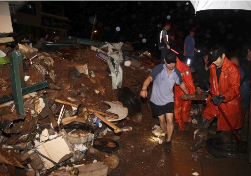
But in New England, landlocked Vermont contended with what its governor called the worst flooding in a century. Streams also raged out of control in upstate New York.

In many cases, the moment of maximum danger arrived well after the storm had passed, as rainwater made its way into rivers and streams and turned them into torrents. Irene dumped up to 11 inches of rain on Vermont and more than 13 in parts of New York.

"We were expecting heavy rains," said Bobbi-Jean Jeun of Clarksville, a hamlet near Albany, N.Y. "We were expecting flooding. We weren't expecting devastation. It looks like somebody set a bomb off."

Meanwhile, the 11-state death toll, which had stood at 21 as of Sunday night, rose sharply as bodies were pulled from floodwaters and people were electrocuted by downed power lines.

The tally of Irene's destruction mounted, too. An apparently vacant home exploded in an evacuated, flooded area in Pompton Lakes, N.J., early Monday, and firefighters had to battle the flames from a boat. In the Albany, N.Y., suburb of Guilderland, police rescued two people Monday after their car was swept away. Rescuers found them three hours later, clinging to trees along the swollen creek.

"It's going to take time to recover from a storm of this magnitude," President Barack Obama warned as he promised the government would do everything in its power to help people get back on their feet.

For many people, the aftermath could prove more painful than the storm itself.

In North Carolina, where Irene blew ashore along the Outer Banks on Saturday before heading for New York and New England, 1,000 people were still in emergency shelters, awaiting word on their homes.

At the same time, nearly 5 million homes and businesses in a dozen states were still without electricity, and utilities warned it might be a week or more before some people got their power back.

"Once the refrigerator gets warm, my insulin goes bad. I could go into diabetic shock. It's kind of scary because we don't know how long it's going to be out for," said Patricia Dillon, a partially paralyzed resident of a home for the disabled in Milford, Conn., where the electricity was out and a generator failed. Her voice cracking, she added: "I'm very tired, stressed out, aggravated, scared."

Russ Furlong of Barrington, R.I., ruefully remembered the two weeks he went without power after Hurricane Bob 20 years ago.

"Hopefully, we won't have to wait that long this time," he said. "Last night we had candles. It was romantic. It was fun. But that feeling doesn't last too long."

Up and down the Eastern Seaboard, commuters and vacationers found their travel plans scrambled. Airlines warned it would be days before the thousands of passengers stranded by Irene find their way home. Some Amtrak service in the Northeast was suspended. Commuter trains between New Jersey and New York City were not running. Trains between the city and its northern suburbs were also disrupted.

Kris and Jennifer Sylvester of Brooklyn sat on a bench in the town center in Woodstock, N.Y., with luggage at their feet and their daughters, aged 4 and 9, holding signs reading, "Need a Ride 2 NYC" and "Help Us, No Bus, No Train." They rode Amtrak out for a long weekend in the country, but were unable to get home.

"We're hoping for anything," Jennifer Sylvester said.

In Vermont, the state's emergency management headquarters stood empty, evacuated because of river flooding from Irene's heavy rains. Rescuers used a boat and bucket loaders to pluck seven people from a swamped mobile home park in Lyndonville.

In upstate New York, authorities were closely watching major dams holding back drinking water reservoirs.

Throughout the region, hundreds of roads were impassable because of flooding or fallen trees, and some bridges had simply given way, including a 156-year-old hand-hewn, wooden, covered bridge across Schoharie Creek in Blenheim, N.Y. In all, more than a dozen towns in Vermont and at least three in New York remained cut off by flooded roads and bridges.

Still, there were glimmers of good news. In Pennsylvania, the Delaware River largely remained in its banks, cresting several feet lower than feared. The forecast for flooding on the Mohawk River in New York also eased at Schenectady, N.Y., where officials had worried that high water might threaten the city's drinking water and sewage treatment plant.

Early estimates put Irene's damage at $7 billion to $10 billion, much smaller than the impact of monster storms such as Hurricane Katrina, which did more than $100 billion in damage. Irene's effects are small compared to the overall U.S. economy, which produces about $14 trillion of goods and services every year.

While hard-hit regions, such as the North Carolina coast, will suffer from lost tourism, rebuilding homes, repairing cars, and fixing streets and bridges should provide a small boost to economy, experts said.

Irene was also good for business at Fantastic Kids Toys in New York City, where sales of board games and arts-and-crafts items surged on Friday and Saturday. "People were buying anything to keep their kids busy," owner Steve Reis said.

Many people were surprised by the destruction that Hurricane Irene wrought in communities far inland. But National Weather Service records show that 59 percent of the deaths attributed to hurricanes since the 1970s have been from freshwater flooding.

As for why the flooding was so bad this time, Shaun Tanner, a meteorologist with the forecasting service Weather Underground, noted that August had been unusually wet, and Irene's sheer size meant huge amounts of rain were dumped over a very large area.

"More attention should have been paid to the torrential rain that Irene was going to dump not only on coastal areas, but also inland. That was clear several days ahead of time," Tanner said.

Hurricane Irene Will Make 2011 a Record Disaster Year (BLOG)

Hurricane Irene is very likely to be the 10th billion-dollar disaster of 2011, breaking 2008's record for number of billion-dollar disasters a year, according to preliminary estimates.

Between the summer floods, tornados, blizzards and drought, 2011 had already racked up nine natural disasters that cost at least $1 billion each, tying 2008's record. If damage estimates hold, Irene would make 2011 a record-breaker.

No one knows what the final toll of Irene will be, but estimates were high as the hurricane churned toward the Carolinas on Friday (Aug. 26) as a Category 2 storm with winds of up to 105 miles per hour (169 kilometers per hour). By 5:00 p.m. ET on Friday, the National Weather Service reported that winds were picking up speed along the North Carolina coast. Hurricane-force winds are expected in that region overnight Friday, with hurricane conditions arriving along the mid-Atlantic coast by Saturday afternoon.

The news agency Bloomberg reported Thursday (Aug. 25) that risk assessor Kinetic Analysis Corp. had estimated that Irene may cause $13.9 billion in insured losses and $20 billion in total economic losses when factors such as lost work hours and disruption of shipping are factored in.

Meanwhile, Roger Pielke, a professor of environmental studies at the University of Colorado, Boulder, wrote on his blog, "it does seem safe to say [Irene's] effects will be widespread and the damage total considerable."

Pielke looked up damage totals from previous storms that followed Irene's track and found inflation-adjusted damage estimates ranging from about $4.9 billion (Storm 8, 1933) to about $46.2 billion (New England storm, 1938). But none of the past storms are good analogues for Irene, Pielke wrote.

"We should expect to see damage along the entire eastern seaboard," Pielke wrote, "as well as a considerable amount of damage from inland flooding (not included in these numbers.)"

Escalating costs of hurricanes

If storms seem more expensive in recent decades, they are. But that's not because storms are making landfall more often or becoming more severe. Rather, a growing population, more buildings along coastlines and a big economy mean that storm disruptions are more costly.

In a 2008 paper published in the journal Natural Hazards, Pielke and colleagues compared hurricane damage from 1900 to 2005, taking into account changes in wealth, inflation, population growth and coastal development. Holding those factors steady, the researchers found that there was no increasing trend of greater damage attributable to the storms themselves over the 20th century.

In other words, there's just more stuff in the way to get damaged, making hurricanes today more costly than in the past.

By the researchers' reckoning, the most damaging single storm was the 1926 Great Miami, which would have cost as much as $157 billion in 2005 dollars. The storm was a Category 4 storm that roared onshore with winds of up to 125 mph (201 kph). After devastating southern Florida, the storm made a second landfall near Mobile, Ala.

Preventing damage

If you're in the path of the storm, experts recommend boarding up windows and taking valuables along in case of evacuation. Damage by Irene may be reduced by as much as a quarter if people follow these steps, said Cecilia Rokusek, a project manager at the Institute for Disaster and Emergency Preparedness at Nova Southeastern University in Florida. [Hurricane Evacuations: Why Some Won't Go]

But Rokusek urged hurricane-threatened residents to keep their priorities straight.

"The most important thing in a disaster is to save your life," she told LiveScience. "The material things can always be replaced."

Previous 2011 disasters

Pre-Irene, economic damage from natural disasters in the U.S. exceeded $35 billion this year, according to a National Climatic Data Center report released in August 2011. Those disasters were:
Upper Midwest flooding (summer): At least $2 billion of damage as of mid-August
Mississippi River flooding (spring and summer): $2 billion to $4 billion in damage
Drought, heat wave and wildfires in the Southern Plains and Southwest (spring and summer): Over $5 billion in damage
Tornadoes (May 22-27): At least $7 billion in damage in central and southern states, including the tornado that struck Joplin, Mo., killing 141
Tornados (April 25-30): At least $9 billion in damage in central and southern states
Tornadoes (April 14-16): More than $2 billion in damage in central and southern states
Tornadoes (April 8-11): Losses exceeding $2.2 billion in central and southern states
Tornadoes (April 4-5): More than $2.3 billion in damage in central and southern states
Groundhog Day Blizzard: $2 billion in damage after a massive winter storm dumped snow across the central, eastern and northeastern sections of the country.

A look at Irene's wake — and what's ahead (BLOG)

BEHIND THE STORM:

• IRENE HITS BAHAMAS — A large and powerful Hurricane Irene roared across the Bahamas on Wednesday, pummeling the country's smaller, less-populated islands while posing less of a threat to the capital, a major tourist destination with 200,000 residents.

• CARIBBEAN DAMAGE — The narrow Cat Island in the southeastern Bahamas took the full force of Irene at its most powerful, whipped by winds that exceeded 120 mph. The exact extent of damage in the island chain was still being tallied, but preliminary reports indicated hundreds of homes were damaged, police said. There were no deaths or major injuries.

• NHC WARNING — The U.S. National Hurricane Center in Miami warned Thursday that an "extremely dangerous storm surge will raise water levels by as much as 7 to 11 feet above normal tide levels over the Bahamas."

• FLORIDA INJURIES — Eight people were injured in rough waters caused by Irene in South Florida.

AHEAD OF THE STORM:

• EVACUATIONS — North Carolina's Carteret County orders evacuations for visitors, Outer Banks residents as Irene is very near. Ocean City, Md., orders thousands to evacuate. New York City mayor orders unprecedented mandatory evacuations for residents in low-lying coastal areas as well as at some hospitals and nursing homes.

• TORNADOES — Tornado watches and warnings were in effect along the East Coast ahead of Irene. A town official in North Carolina said witnesses believed a tornado spawned by the hurricane lifted the roof off the warehouse of a car dealership in Belhaven on Friday night and damaged a mobile home, an outbuilding and trees.

• TRANSPORTATION — New York City orders buses, planes and its entire subway system to be shut down as Irene marches up the East Coast. Hundreds of thousands of airline passengers will be grounded this weekend at some of the nation's busiest airports.

• SPORTS — Before it hit land, Irene trimmed at least 18 holes off the PGA Tour's first playoff event and forced several more schedule changes and cancellations along the East Coast.

• BROADWAY — Theater producers in New York decided not to mess with Irene's drama and canceled weekend shows both on and off-Broadway.

• HURRICANE WARNINGS — Hurricane warnings have been issued for North Carolina, Virginia, Washington, D.C., Maryland, Delaware, New York, Pennsylvania and New Jersey.

• OBAMA DECLARES EMERGENCY — President Barack Obama has declared emergencies for North Carolina, Virginia, New York, Connecticut and Massachusetts ahead of Irene.

• NAVY WARSHIPS — U.S. Navy orders ships in big Virginia base to sail for safer waters ahead of Irene.

Transit in NYC, NJ, Pa. to halt because of Irene (BLOG)

ALBANY, N.Y. (AP) — Commuter transit systems in New York, New Jersey and Philadelphia will shut down services because of Hurricane Irene.

New York Gov. Andrew Cuomo says public transportation in New York City will shut down at about noon on Saturday. According to the governor's office, the Metropolitan Transit Authority will institute a system-wide shutdown when subways and buses begin their final runs starting at approximately noon.

The shutdown will include the Long Island Rail Road, Metro-North Railroad and Access-A-Ride. The last complete shutdown of the system was for a 2005 strike.

New Jersey Transit trains also will stop running at noon Saturday. Gov. Chris Christie made the announcement during a briefing on the storm Friday.

In Philadelphia, Mayor Michael Nutter says mass transit in Philadelphia and its suburbs will halt at 12:30 a.m. Sunday.

To stay or go? Officials ponder Irene evacuations (BLOG)

HATTERAS, N.C. (AP) — Hurricane Irene could hit anywhere from North Carolina to New York this weekend, leaving officials in the path of uncertainty to make a delicate decision. Should they tell tourists to leave during one of the last weeks of the multibillion-dollar summer season?

Most were in a wait-and-see mode, holding out to get every dime before the storm's path crystalizes. North Carolina's governor told reporters not to scare people away.

"You will never endanger your tourists, but you also don't want to over inflate the sense of urgency about the storm. And so let's just hang on," North Carolina Gov. Beverly Perdue said Wednesday. At the same time she warned to "prepare for the worst."

In the Bahamas early Thursday, the head of the National Emergency Management Agency says that at least two settlements have been devastated on the southern islands of Acklins and Crooked. Capt. Stephen Russell says an official there reports that 90 percent of the homes in the settlements have been severely damaged or destroyed. Several hundred people live on each island. No injuries have been reported.

They were among the first to be hit Wednesday as the hurricane made its way up the chain. Tourists cut their vacations short and caught the last flights out before the airport was closed.

Irene has already hit Puerto Rico and the Dominican Republic, causing landslides and flooding homes. One woman was killed.

No warnings or watches were out for North Carolina though they were likely later Thursday. But on its Outer Banks, some tourists heeded evacuation orders for a tiny barrier island as Irene strengthened to a Category 3 storm, with winds of 120 mph (193 kph).

By Thursday, that could intensify to a monstrous Category 4 hurricane with winds starting at 131 mph (210 kph).

"We jam-packed as much fun as we could into the remainder of Tuesday," said Jessica Stanton Tice of Charleston, W.Va. She left Ocracoke Island on an early-morning ferry with her husband and toddler.

"We're still going to give North Carolina our vacation business, but we're going to Asheville" in the mountains, she said.

Officials said Irene could cause flooding, power outages or worse as far north as Maine, even if the eye of the storm stays offshore. Hurricane-force winds were expected 50 miles from the center of the storm.

Predicting the path of such a huge storm can be tricky, but the National Hurricane Center uses computer models to come up with a "cone of uncertainty," a three-day forecast that has become remarkably accurate in recent years. Forecasters are still about a day away from the cone reaching the East Coast. A system currently over the Great Lakes will play a large role in determining if Irene is pushed farther to the east in the next three or four days.

The mood was calm in Virginia Beach, Va. Jimmy Capps, manager of the Breakers Resort Inn, said the 56-room hotel is about 80 percent booked for the weekend, despite a few cancellations.

"It just appears they're not quite sure what the storm is going to do," Capps said. "The thing I'm amazed at now is that we haven't had more cancellations so far. Usually when they start mentioning the Outer Banks and Cape Lookout, which we are between, the phones light up."

In nearby Norfolk, the Navy ordered the Second Fleet to prepare to move out to sea early Thursday to keep the ships safe from the storm.

In New England, some beachgoers started second-guessing vacation plans. Steven Miller, who runs a charter sport fishing company off the coast of Rhode Island, hasn't received any cancellations, but no one has been calling to schedule trips in the next few days, either.

"The hoopla beforehand could end the season," Miller said. "Everybody yanks their boats out, everybody leaves, and then they don't come back because it's so late in the season."

Sandbags were in demand in the Northeast to protect already saturated grounds from flooding. Country music star Kenny Chesney moved a Sunday concert in Foxborough, Mass., up to Friday to avoid the storm. High school football games were also rescheduled, and officials still hadn't decided whether to postpone Sunday's dedication of the Martin Luther King Jr. memorial on the National Mall. Hundreds of thousands were expected for that event.

"Tourism depends so much on the weather, which is such an unpredictable element," said Samantha Rich, a tourism extension specialist at North Carolina State University. "An extremely hot season, an extremely cold season, a hurricane — it can make or break a season, especially for small businesses."

In North Carolina's Outer Banks, where about 300,000 visitors come every week in the summer, tourism is the lifeblood of the towns that dot the sandy barrier islands. Dare County beaches are the state's top vacation destination and it ordered tourists out beginning Thursday morning. Tourism represents about $834 million for businesses in the county, which has 8,000 rental homes and 3,000 hotel rooms, plus campground spots.

Business owners are wary of sacrificing a weekend in August if it's not completely necessary.

"We had that occur last year, with Earl," said Veda Peters, co-owner of the Cypress House Inn in Kill Devil Hills. He was referring to the hurricane that passed off to the east, bringing little more than a night of rain and some wind gusts. "They evacuated the county, and then Labor Day weekend was gorgeous in the Outer Banks."

So far, the Cypress House Inn is fully booked for the coming weekend, but Peters already is getting calls about the weather.

"If it's safe for people to be here, we want them to be here. If it's not safe, we'll say so and we'll get you in as soon as it is," said Lee Nettles, managing director or the Outer Banks Visitors Bureau. "We have a peak summer season and we're in the midst of that."

Dangerous hurricane Irene threatens U.S. Northeast (BLOG)

NASSAU (Reuters) - Powerful Hurricane Irene battered the Bahamas on Wednesday on a track to the North Carolina coast that forecasters say could threaten the densely populated U.S. Northeast, including New York, starting on Sunday.

Irene, a major Category 3 storm with winds of 120 miles per hour (195 km per hour), pounded the southeast Bahamian islands with winds, rain and dangerous storm surge. Tourists fled the storm and major cruise lines canceled Bahamas stops.

The first hurricane of the storm-filled 2011 Atlantic season was expected to gain strength after it leaves the Bahamas on Thursday and race across open waters to clip North Carolina's jutting Outer Banks region on Saturday.

After that, forecasters see it hugging the U.S. eastern seaboard, swirling rains and winds across several hundred miles (km) as it churns northward toward New England.

"The exact center of the storm may actually stay pretty close to the coastline during the day on Saturday and then become a big threat for New England and perhaps Long Island ... on Sunday," U.S. National Hurricane Center Director Bill Read said.

"Be advised, it's going to be a very large circulation as it moves north of the Carolinas," he told a conference call.

Read said North Carolina could get tropical storm-force winds as early as Saturday morning.

DANGEROUSLY WIDE HURRICANE

At 11 p.m. EDT (0300 GMT), Irene's center was about 150 miles east-southeast of Nassau, the capital of the Bahamas, and about 790 miles south of Cape Hatteras, North Carolina.

If Irene makes a direct landfall in the continental United States, it will be the first hurricane to hit there since Ike pounded Texas in 2008. But forecasts showed it posing no threat to U.S. oil and gas installations in the Gulf of Mexico.

Irene's torrential rains were blamed for two deaths in the northeast Caribbean islands. A woman in Puerto Rico and a Haitian man in the Dominican Republic were swept away by floodwaters from overflowing rivers.

States from the Carolinas northward were on alert and visitors were ordered to evacuate many of North Carolina's Outer Banks barrier islands on Thursday.

New York Governor Andrew Cuomo ordered the state's Office of Emergency Management to prepare for possible impact from Irene. Insurers kept a nervous watch in case Irene threatened wealthy enclaves such as the Hamptons, an eastern Long Island playground for New York's rich.

Forecasters warned that even if the center of the hurricane stays offshore as it tracks up the mid-Atlantic coast, its wide, swirling bands could lash cities including Washington and New York with winds and rain, knock out power, trigger coastal storm surges and cause flooding.

"We're not paying attention just to the eye of the storm. We're looking at how wide it is, how large it is," Virginia Emergency Management Department spokeswoman Laura Southard said.

"STOCKING UP LIKE CRAZY"

Earlier on Wednesday, Irene strengthened over the Bahamas to a major Category 3 hurricane on the five-step Saffir-Simpson intensity scale, posing a high risk of injury and death. Forecasters said it could become a Category 4 by Thursday.

"Someone's roof is in my front yard," Harvey Roberts, an assistant administrator on the sparsely populated southeast Bahamas island of Mayaguana, told reporters on Wednesday, saying "tremendous winds" were lashing homes and buildings there.

Farther north on the scattered low-lying Bahamas, including Nassau, residents were frantically preparing.

"Everyone is either pulling up boats or putting up shutters. We are very well prepared," said Chuck Pinder, a 28-year-old fisherman in the community of Spanish Wells.

NHC chief Read predicted a "really tough time" for the Bahamas as Irene swept through Wednesday and Thursday.

Irene dealt a blow to the crucial tourism industry of the Bahamas. Cruise lines rearranged itineraries for more than a dozen ships in the area and tourism officials said the loss of those passenger visits would cost the Bahamas almost $2 million in tax revenues and other spending. Hotels also saw guests cancel or cut short their visits.

Energy firms planned to shut more than 28 million barrels of oil storage capacity in the Bahamas and refineries on the U.S. East Coast were preparing for the storm.

On the U.S. mainland, across the Carolinas coastline and in neighboring Virginia, residents stocked up with food, water and other supplies, including plywood to board up windows.

"There are people stocking up like crazy -- we're out of generators," said Tracy Hatfield at the Sam's Club members-only warehouse at Chesapeake Square.

Irene weakens but remains big threat to US (BLOG)

WILMINGTON, N.C. (AP) — People stocked up on food, boarded windows and gassed up their cars Tuesday as Hurricane Irene threatened to become the most powerful storm to hit the East Coast in seven years.

Water, bread and batteries disappeared from store shelves. Lines formed at the pump. From Florida to Maine, residents were told to brace for flash flooding and power outages.

Hundreds of miles south, Irene swirled through the Caribbean, giving a glimpse of what was to come. Homes were inundated with water, residents took refuge in schools and churches, and more than a million people were without electricity. One woman was killed in Puerto Rico.

Forecasters warned it could get worse: The storm was likely to strengthen into a Category 4 monster by the time it makes a landfall in the U.S. this weekend, most likely hitting North Carolina. Irene could crawl up the coast Sunday toward the Northeast region, where residents aren't accustomed to such storms.

Officials dusted off evacuation plans and readied for the first hurricane to threaten the U.S. in three years. It's been more seven years since a major hurricane, considered a Category 3 with winds of at least 111 mph (179 kph), hit the East Coast. Hurricane Jeanne came ashore on Florida's east coast in 2004.

Though Irene was downgraded to a Category 1 storm on Tuesday with maximum sustained winds of 90 mph (145 kph), forecasters believed it would strengthen over warm waters.

"I'm not panicking, but I was born and raised here," said Peggy Temple, of Wrightsville Beach, N.C.

She bought sandbags to protect her first-floor property from flooding.

"I know the drill. You want to be ready, because you can't be putting up storm shutters with 100 mile an hour winds and torrential rain," she said.

Nearby, scores of bronzed sunbathers strolled around in bathing suits and towels, soaking up one of the last weeks of the summer tourist season. Traffic was typical for this time of year, with more cars headed toward the beach than away from it, though some vacationers had started canceling weekend hotel reservations.

On Ocracoke Island, tourists and residents were told to leave by Thursday so the island's ferries wouldn't be overwhelmed. But many on the 16-mile-long barrier island would probably stay, said Tommy Hutcherson, who serves on the local board that issues evacuation orders.

"I'll be here," said Hutcherson, who has lived on Ocracoke for 29 years. "A lot of the locals will choose to stay."

Bob Eure, who works at the Island Tackle & Hardware in Carolina Beach, said people streamed in all day, buying flashlights and five-gallon gas cans to fill with water. Others bought fish tackle.

"With the water stirred up, the fish will bite better," he said.

Still, Eure said, people are worried, particularly those who have moved to the area from other parts of the country.

"It's still too early and we don't know where it's going to hit, but everyone is getting ready. You have to prepare yourself for the storm," he said.

The last hurricane to hit the U.S. was Ike in 2008. The last Category 3 or higher to hit the Carolinas was Bonnie in 1998, but caused less damage than other memorable hurricanes: Hugo in 1989, Floyd in 1999 and Isabel in 2003.

Though a Category 2, Isabel cut a new inlet through Hatteras Island and killed 33 people.

In Washington, the National Park Service considered postponing Sunday's dedication of the new Martin Luther King Jr. memorial. Hundreds of thousands of people were expected on the National Mall.

As far north as Maine, residents were told they could be affected by Irene.

"We need to remind people, hurricanes are not just a Southern thing. This could be the Mid-Atlantic and the northeast coast," Craig Fugate, head of the Federal Emergency Management Agency, said during a conference call with reporters. "We've got a lot of time for people to get ready, but we don't have forever."

Even if the storm stays offshore, it could cause flooding and power outages all along the Eastern Seaboard. National Hurricane Center director Bill Read drew comparisons to a 1938 hurricane that also approached from the South and killed 682 people in New England.

"We're very concerned about what's going to happen in New England," Read said.

The hurricane's projected path has gradually shifted farther east. Forecasters initially expected the storm to hit Florida.

Irene has already wrought destruction across the Caribbean. In Puerto Rico, more than a million people were without power, and a woman died trying to cross a swollen river in her car. President Barack Obama has declared an emergency there. Hundreds were displaced by flooding in the Dominican Republic, forced to take shelter in schools and churches.

Magnitude 5.5 earthquake hits southern Colorado (BLOG)

GOLDEN, Colo. (AP) — A magnitude 5.3 earthquake shook southern Colorado late Monday, waking some people up and startling hundreds of others in a sparsely populated region near the New Mexico border.

The quake — the largest to strike Colorado in a decade — followed two smaller ones that hit the area earlier in the day: A magnitude 4.6 quake was felt at 5:30 p.m. and a magnitude 2.9 quake was recorded just before 8 a.m. The 5.3 earthquake was recorded at about 11:46 p.m. MDT Monday about five miles west of Cokedale, Colo., according to the National Earthquake Information Center in Golden, Colo.

The center is part of the U.S. Geological Service.

A Las Animas County Sheriff's Office dispatcher said she had received calls from "tons" of county residents who felt the shaking, as well as reports of rockslides along a highway following the quake. USGS geophysicist Jessica Sigala said the quake has the potential of causing minimal damage.

Another USGS geophysicist, Shengzao Chen, said the center had received calls from more than 70 people in Trinidad, Colo., who felt the shaking, as well as several dozen people in New Mexico. More than 30 people in Colorado Springs, about 130 miles from Cokedale, also reported feeling the quake, he said.

The last time the area received a series of earthquakes was in 2001, when about a dozen smaller-sized temblors were recorded, Chen said.

"The area seems to be active again," he said.

Hurricane Irene strengthens on its way to Fla., Carolinas (BLOG)

(USATODAY)Hurricane Irene, now packing 100-mph winds that make it a Category 2 hurricane, passed Monday north of the island of Hispaniola, home to Haiti and the Dominican Republic, and was heading for the Bahamas.

The move prompted a warning from the National Hurricane Center in Miami that the storm will likely intensify to a Category 3 storm with winds of 115 mph over the Bahamas by Thursday.

INTERACTIVE: Track the hurricanes of 2011

"Residents of Florida and the southeastern U.S. should be keeping their eyes on this storm and have their hurricane supplies ready now," hurricane center spokesman Dennis Feltgen says. "No one wants to be standing in line at the hardware store when a storm hits."

More than a million people in Puerto Rico saw their power cut off Monday, as Irene passed about 105 miles west of San Juan. No injuries were reported. The storm also walloped the British Virgin Islands, bringing lightning that was the likely culprit in a fire that destroyed billionaire Richard Branson's Caribbean home. Guests, including the Academy Award-winning actress Kate Winslet, escaped the fire uninjured.

The center of the storm's 500-mile-wide projected path now is on track to hit South Carolina on Saturday, although Feltgen says its path could change. In the best case, a low-pressure center could push the storm away from the coast late in the week.

The National Weather Service said odds were higher that Irene would make landfall as a Category 1 hurricane rather than Category 3.

"No one should just look at the center of the track and think they are clear," Feltgen says. "A major storm covers a lot of area."

Warmer-than-normal Gulf Stream waters and light upper-air winds off the U.S. coast are expected to spur the intensification of the storm.

The hurricane center projects a 70% chance of three to five major storms this hurricane season, which started on June 1. No hurricane has hit U.S. coasts since Hurricane Ike in 2008, which killed 112 people in Galveston, Texas.

Florida and the Carolinas have largely escaped hurricanes since the heavy storms of 2005.

"That might breed complacency," says hurricane scientist Phil Klotzbach of Colorado State University in Fort Collins. "But we have the heart of the season right ahead of us."

Hurricane warnings issued as Irene approaches (BLOG)

MIAMI (AP) — A hurricane warning was issued Sunday for Puerto Rico and the northern Coast of the Dominican Republic as Tropical Storm Irene dumped heavy rain in the Caribbean.

The storm could hit southern Florida by the end of the week.

Forecasters at the U.S. National Hurricane Center in Miami said Irene could become a hurricane by Monday. On Sunday, the storm had maximum sustained winds of 50 mph (80 kph) and was moving west-northwest at 20 mph (32 kph). Sustained winds must reach 74 mph (119 kph) for the storm to become a hurricane.

The warning in the Dominican Republic stretches from its border with Haiti in the south to Cabo Frances Viejo on the north coast.

Meanwhile, a hurricane watch has been issued for the U.S. Virgin Islands. A tropical storm warning is in effect for Haiti, the U.S. Virgin Islands and other islands.

Irene was 235 miles (378 kilometers) east-southeast of Ponce, Puerto Rico. It was expected to pass near Puerto Rico sometime late Sunday or early Monday.

Tropical storm warnings have been issued for the U.S. Virgin islands as well as a host of nearby islands.

Irene could bring dangerous storm surge to the coasts of Puerto Rico and the Dominican Republic.

Also Sunday, Harvey trekked westward across southeastern Mexico with heavy rains. Recently downgraded to a tropical depression, Harvey was located at about 125 miles (201 kilometers) east-southeast of Coatzacoalcos, Mexico.

Harvey had maximum sustained winds of 30 mph (48 kph) and was forecast to dissipate over southern Mexico by Sunday night. The system still could produce several inches of rainfall over parts of southeastern Mexico.

Severe weather leaves thousands without power in Kentucky (BLOG)

(Reuters) - Severe thunderstorms across southwest Indiana and into Kentucky left about 74,000 Louisville customers without power on Sunday, officials said.

The windy rains rolled through late on Saturday, and nearly 130,000 customers were in the dark at the peak of the storms, according to LG&E-KU Energy spokesman Chip Keeling.

Louisville, Kentucky was the hardest hit, according to the National Weather Service, although reports of wind damage and hail were recorded from Crawford County, Indiana to Lexington, Kentucky.

Roughly 1,000 wires were downed after the city was hit by gusts of wind up to 70 mph, Keeling said.

About 74,000 customers in Louisville remained without power by mid-day on Sunday, he said.

More than 400 technicians and tree trimmers were working to restore power, and another 900 workers from eight nearby states were expected on the ground by Monday, he said.

"It's going to be a couple days. We're probably looking at Wednesday," Keeling said, before power is completely restored.


Monday was supposed to be opening day at public schools in Louisville, but Mayor Greg Fischer said via Twitter that local schools would be closed.

More than two dozen schools were affected by the power outage, Keeling said, and downed wires and darkened traffic lights could also make for a messy first day of school.

According to the Weather Service, most of the damage was caused by powerful vertical winds, possibly in the form of downbursts, which can cause damage similar to low-grade tornadoes.

The heavy storms over South Korea

The heavy storms over South Korea today created landslides in mountainous Gangwon Province and in the capital city of Seoul that killed at least 18 people. At least three others are missing. South Korea has been pummeled with strong rain this week.
Byun In-soo of the town's fire station said, Ten of the 13 people killed in an early morning landslide in Chuncheon, about 68 miles northeast of the capital Seoul, were college students who had been doing volunteer work. They were staying in a resort cabin when the mud and debris engulfed them. Also killed were a married couple and a convenience store owner.

Officials said, About 500 officials and residents worked to rescue people trapped in the mud and wreckage. Twenty-four people were injured and several buildings destroyed,


About 15 inches (400 millimeters) fell in Seoul in just 17 hours starting Tuesday afternoon. More than 10 inches (250 millimeters) fell on Chuncheon in the last two days. Weather officials said another 10 inches could fall in northern South Korea, including Seoul, through Friday.

Fast-moving muddy water filled streets in Seoul on Wednesday, with people scrambling to the roofs of their partially submerged cars. Water filled some subway stations and spewed from sewers.The official said 23 roads were closed in the city.

The Seoul Metropolitan Police Agency issued a traffic emergency, mobilizing more officers to deal with the problems caused by the heavy rain.

Seoul officials said they were considering shutting down two major city highways stretching along each side of the main Han River because of rising water levels. Cha Jun-ho, an official at the government's Han River Flood Control Office, said a dam located just east of Seoul was discharging 16,400 tons of water per second. The dam discharged about 1,000 tons per second days before the recent downpours began.

About 60 houses were cut off from roads in Seoul's Hyeongchon village because of the heavy rain, and fire officials were trying to rescue them, a local officer said, declining to be identified because of office procedure.

Mapping Ancient Algorithms for Artificial Weather and Atemporal Seasons

Ancient Merv

Liverpool Tornado

Anthony McCall


As part of the 2012 Cultural Olympiad, artist Anthony McCall will be spinning an artificial, mile high tornado in Liverpool. Called Column, this swirling micro-climate will be created “by gently rotating the water on the surface of the [River] Mersey and then adding heat which will make it lift into the air like a water spout or dust devil.”

Outside with the “[in]coherent convection” of the elements and without the controlled environment of some cavernous atriums, no doubt McCall and his engineering team will encounter some complications. But we're hoping the final piece will look as legible as the image, or at least on favorable days.

California Super Storms Could Be Worse Than Earthquakes!! (Blog)

A group of more than 100 scientists and experts say in a new report that California faces the risk of a massive "superstorm" that could flood a quarter of the state's homes and cause $300 billion to $400 billion in damage. Researchers point out that the potential scale of destruction in this storm scenario is four or five times the amount of damage that could be wrought by a major earthquake.
It sounds like the plot of an apocalyptic action movie, but scientists with the U.S. Geological Survey warned federal and state emergency officials that California's geological history shows such "superstorms" have happened in the past, and should be added to the long list of natural disasters to worry about in the Golden State.
The threat of a cataclysmic California storm has been dormant for the past 150 years. Geological Survey director Marcia K. McNutt told the New York Times that a 300-mile stretch of the Central Valley was inundated from 1861-62. The floods were so bad that the state capital had to be moved to San Francisco, and Governor Leland Stanford had to take a rowboat to his own inauguration, the report notes. Even larger storms happened in past centuries, over the dates 212, 440, 603, 1029, 1418, and 1605, according to geological evidence.
The risk is gathering momentum now, scientists say, due to rising temperatures in the atmosphere, which has generally made weather patterns more volatile.
The scientists built a model that showed a storm could last for more than 40 days and dump 10 feet of water on the state. The storm would be goaded on by an "atmospheric river" that would move water "at the same rate as 50 Mississippis discharging water into the Gulf of Mexico," according to the AP. Winds could reach 125 miles per hour, and landslides could compound the damage, the report notes.
Such a superstorm is hypothetical but not improbable, climate researchers warn. "We think this event happens once every 100 or 200 years or so, which puts it in the same category as our big San Andreas earthquakes," Geological Survey scientist Lucy Jones said in a press release.
Federal and state emergency management officials convened a conference about emergency preparations for possible superstorms last week. You can read the whole report here.

ANOTHER 7.1 MAGNITUDE EARTHQUAKE HITS CHILE!!! (BLOG)


Santiago – A 7.1-magnitude earthquake shook the souther part of Chile and costs thousands of people to evacuate as fear of tsunamis increased.
According to the National Emergency Office, there were no reports of casualties and damages to properties. There was also no tsunami alert released by local officials.
Vicente Nunez, head of the National Emergency Office of Chile said in a statement that there were no people harmed because of the earthquake.
The United States Geological Survey said that the epicenter of the earthquake was located near the coast of Tirua. Tirua is about 385 miles from Santiago, the capital city of Chile. The U.S. Geological Survey also said that it occurred at 2020 GMT at a depth of 10 miles. An aftershock that followed was later measured to be 5.0 in magnitude.

Photo shows houses destroyed by an 8.8-magnitude earthquake in Chile last February 2010.
Chilean President Sebastian Pinera said they have asked the people to seek higher ground as a precautionary measure but added that they should all remain calm. Pinera also said that they were very fortunate that they do not have any casualties.
There were no major problems experienced because of the quake aside from power outages and interruptions in communications services.
Hundreds of people evacuated on higher grounds in their cars after the incident and thousands more followed including tourists. According to local officials, there was no danger of a tsunami as the quake occured on land and not on sea. The Hawaii-based Pacific Tsunami Warning Center also said that a destructive tsunami is not to occur.
It was just last year in February wherein a strong earthquake, measuring 8.8 in magnitude, struck Chile. The earthquake resulted in tsunamis that killed more than 500 people and left at least 200,000 others homeless.
gettingthedealnews.com

12/21/2010 Winter Solstice, Lunar Eclipse in 1 Minute 30 Seconds!! (Video)


Tuesday’s lunar eclipse was the first time that it has coincided with winter’s solstice since 1638, 372 years!
So you tried to stay up, you tried to watch it, After about 20 Minutes you fell asleep. All the hype..... its the First solstice since 1638...the Next one wont be until 2094!! You missed the day when the Earth, Moon and Sun aligned well never fear! Stadium Status is here! we got you!