
Showing posts with label littoral. Show all posts
Showing posts with label littoral. Show all posts

Dune Field

Rietveld Landscape's Interaction between elements is a set of flexible strategies for dealing with sea level rise on Terschelling, one of the West Frisian Islands off the coast of the Netherlands.
The Wadden See and the south side of the Boschplaat [a nature reserve] will grow with the rising of the sea level because of sand replenishments in front of the coast. The northern part of the Boschplaat is unable to grow in this way. There, the existing drift dike will be activated by removing the current vegetation. A huge drifting sand dune will consequently develop. A grid of old mooring bollards ensures that the processes of sand drift and dune formation are readable through time. After years of heightening, a series of perforations in the drift dike is now proposed. These carefully selected perforations will bring about new wash-overs. In this way, an exciting interaction between the power of the seawater, the bollard grid and the dune formation process is created. The Boschplaat will grow with the rising of the sea level and will become ecologically more valuable because of the wash-overs. Both the role of human intervention and the dynamics of the interaction between the elements are made visible by Rietveld Landscape’s design.
Worth comparing this lo-fi accretionary strategy with that of Fabrizio Matillana's parametric Marsh Condenser.


Recycled fishing nets hung between some of the bollards might quicken the pace of dune building.
Embassy of the Drowned Nations

A co-winner in the Sea Change 2030+ ideas competition, the Embassy of the Drowned Nations is a proposal by the Sydney-based landscape architecture office OCULUS for an inverted Ellis Island sunk in the middle of Sydney Harbour.
Here, in this “blend of Atlantis and Eden,” refugees from former island nations are welcomed and “given the opportunity to grieve, to rest, to recuperate, to learn and to eventually rise up and join Australian society.”
Apart from temporary housing, the embassy will also host a research and cultural center devoted to climate change.
Super-Slurry

A few more since the last self-link-o-rama:
1) The self-replicating, self-similar geology of San Lucido: geo-efflorescences on the Italian coast.
2) The Ocean Pools of Madeira (and Sydney): Suprematist fractalogy on the coast of Australia.
3) Cedar Island: If you build it, rich Lebanese expatriates will come. Maybe.
4) San Francisco As It Will Be: an ideas competition.
5) The Tide Pool of Saint-Malo: an Atlantic exclave.
6) Flemish Island Constellation: the Office of Permanent Modernity's anti-Dubai.
7) This Land Is Really Your Land: returning to the beaches of Malibu.
8) Reclaiming Saemangeum: the future Dubai of Northeast Asia.
9) Buy a lighthouse and get off the beach!
10) Morris Island Lighthouse: an immovable geoglobule secreted by its parent island. #glacierislandstorm
11) Site Specific: documenting the imminent destruction of a house teetering on a cliff edge.
12) Trestles Beach Access Competition: organized by Architecture for Humanity.
13) Sea Change: our ur-beach.
14) Soft Pavilions: a herd of nomadic cybergeoglobules.
15) Slurry #1 #2 #3 #4.
Slurry #4

And here's the next batch.

SOAK: Mumbai in the Estuary by Anuradha Mathur and Dilip da Cunha looks at Mumbai’s terrain and the history of its making. It images the sea and the monsoon not as enemies and agents of flood, but as inevitable partners in the shaping of the ground of settlement.
It situates Mumbai in a fluid threshold between land and sea, a shifting saline and fresh water gradient of creeks, and a monsoon surface of holdings. The ground between land and sea is understood to be a filter in section drawings, photographs and models that present this alternative representation of Mumbai’s terrain.
SOAK also showcases design interventions that holds waters rather than channel it out to sea; that work with the gradient of an estuary. It calls for visualizing the city as a fluid field of rain-soaked surfaces, monsoon holdings and overflows, of public-private negotiations.
Rather than fighting the monsoon, it encourages us to design with and enjoy the soak.
Here's a brief excerpt from BBC's Coast on artificial coastlines and mobile floating harbours constructed in secret all over Britain for the Normandy invasion.
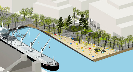
“Sugar Beach is the second urban beach proposed for Toronto’s downtown waterfront, and the latest addition to the amber necklace of Toronto’s lakefront beachscape. It is a sequel to HtO, the waterfront’s first beach park. The proposal for Jarvis Slip playfully recomposes other signature elements of the city, with Toronto playing the role as its own design precedent. The omnipresent horizon of the lake and adjacent industrial buildings recalls Georges Seurat’s Bathers at Asnières (1884). Tinted by sugar spray carried on westerly breezes from the neighboring Redpath Sugar Factory, a series of hard rock candies with colored stripes and dozens of pink umbrellas are scattered across a sandy wedge of beach along the Jarvis Slip. Integrating the future Waterfront Promenade, along with a plaza for programmed and unprogrammed events, the design playfully adopts some of the most enduring elements from Toronto’s emerging landscape identity—beaches, bedrock, trees, and water—as well as the urban horizon and a trace of the city’s past industrial mood.”
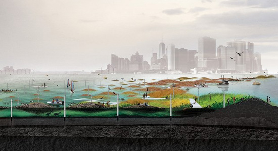
“Oyster-tecture is a project created for Rising Currents, an exhibition jointly sponsored by the Museum of Modern Art and the PS1 Contemporary Art Center that commissioned design responses to climate change and sea level rise on the NYC waterfront. Our team, led by Kate Orff, participated in an 8-week design and planning workshop at PS1 with a team of local engineers, ecologists, and high school environmental activists to develop the proposal. Inspired by local restoration efforts underway, we propose an offshore wave attenuation oyster-reef and a water-based inland to protect the city’s waterfront from climate changed-induced sea level rise and storm surge. By improving water quality, attenuating waves, and building habitat, Oyster-tecture introduces new strategies for water-based recreation, ecologies, and economies to the residents of New York.”
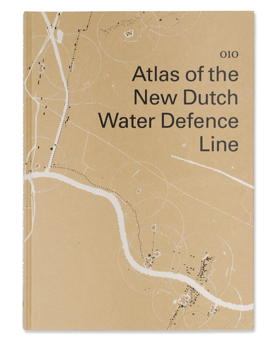
“This atlas addresses the New Dutch Water Defence Line (Nieuwe Hollandse Waterlinie) on a themed basis. Its position in the landscape, the forts, the inundation system, the geomorphology, the strategic system and recent developments can be read off in maps rendered so as to give an understanding of all aspects of the defence line landscape. The defence line reveals itself as a many-tentacled military defensive system of forts, group shelters and polders which can be flooded at the threat of war. The maps show the cohesion of the defence line as a landscape-strategic structure as well as the topographic composition of this structure in layers and components. The more detailed maps of the forts display the wealth of historic places, insertions in the landscape and defining elements.”

In the Safe Trestles Beach Access competition, our favorite finalist is The Long Trail, submitted by Ken Smith Landscape Architect.
Writes the design team, “Our approach is straight forward incorporating ADA access and providing a safe at-grade crossing. The path follows the topography by tracing desire lines. Existing use patterns are utilized for a minimal footprint of path infrastructure. This strategy encourages ecological restoration, reduces runoff, improves water quality, and provides additional habitat.”

The Tarlair Swimming Pool is a tidal pool cozily tucked into a cove on the northeast coast of Scotland, near Macduff. First opened in the 1930s, it became a popular, even fashionable, social meeting place. During low tides, it provides safe areas for swimming and wading, and at high tides, the sea replenishes its waters by engulfing all areas of the pool. Built in the Art Deco style, its expressive curves, white washed geometric tea pavilion and Suprematist pool stand in awesomely beautiful stark contrast against the craggy landscape.
Tarlair has fallen in disrepair since it was closed in 1995. In 2007, it was awarded A List status, the highest rating, by Historic Scotland in recognition of its “simple yet stylish design, early date and magnificent location.” This status gave the pool legal protection but not immediate funding for restoration.
See also the tide pool of Saint-Malo.
#1 #2 #3
Slurry #3

Here, we're less interested in the Massimo Vitali photograph itself than what it has captured: more or less a construction scaffolding smoothing out a patch of irregular terrain.
Less designery and messier than Vicente Guallart's microcoasts and hexagonal beaches, this seemingly ad hoc intervention creates an occupiable public open space on the rugged coastline of Catania, Sicily, where before only the daring few ventured out. Simultaneously, the structure provides an easy and safe access to the waters of the Mediterranean, an important recreational asset to the local community as well as an obvious exploitable asset for its tourism industry.
#1 #2
Slurry #2: Marsh Condenser

We continue our time-saving survey of projects situated on that ambiguous line separating land and water with Fabrizio Matillana's Marsh Condenser, one of the ecoMachines coming out of Claudia Pasquero and Marco Poletto's studio at the AA.

Matillana describes his ecoMachine as “an evolutionary infrastructure situated in the Essex estuary, restoring lost marshland ecologies through a park typology based on sediment collecting ‘folies’ [sic] bridging the dynamic flood cycles of the site and the public that visit the natural reserve.”

These follies act “as a combination of hard and soft engineering technique to increase accretion levels within the test site which is necessary to stabilize marshland in risk. Soft engineering in the sense that it is highly sensitive to its positioning in relation to the environmental dynamics and stresses that contribute to the preservation or destruction of a marshland ecology. Hard engineering in its material presence acting as ‘sediment corset’ and allowing an architectural intervention that embeds itself within the emerging ecology.”


Slurry #1
Slurry #1

From time to time we'll gather some of the coastal debris that have been cluttering our desktops, bookmarks, inboxes, newsreaders and post queue for months (years, in a few cases), and bundle them together into a single post. It'll be a rush job.

The U.S. Geological Survey reviews the proposal to build sand berms along the Louisiana coast to prevent oil from the Deepwater Horizon oil spill from reaching interior marshes.

Lebbeus Woods has proposed “the construction of a terrace along the six-kilometers of The Malecón, which is dedicated to public recreation, a type of urban park or abstract beach cantilevered from The Malecón over the sea. Shelter from the sun is built into the layers of each structurally independent terrace segment, which rests on heavy steel hinges such as those used for modern drawbridges. The independent segments can be built one at a time, and also shaped to the curving line of the roadway, so that their ensemble is continuous. Most importantly the segments can be designed to accommodate differing recreational needs along its six-kilometer extent; for example, a set of terrace segments serving one neighborhood could be very open, while another, serving a different neighborhood, could provide more layers of shelter and semi-enclosed spaces.”

From Smout Allen's Augmented Landscape:
“The estuaries of Essex form a liquid edge to the county. This fragile boundary, which extends and retracts with the ebb and flow of the tide, reinforces the connection between the sea and the land. The proposal responds to the current thinking on a managed realignment of the coast, removing hard sea defenses such as sea walls and embankments that prevent the natural landward movement of the salt marshes, and allowing the land to be flooded by the incoming tide. Returning land to salt marsh encourages brackish vegetation and establishes the flood plain as an environmental bugger. A shallow plate is inserted into the intertidal zone, lying low on the horizon. The plate beds into the mud flats, with its extremities in the retreating tide and reaching up to the higher grass land beyond.
“Three territories are formed: oyster lanes fed by nutrient-rich runoff from the salt marsh and high tide, grazing land, and a market. The panorama is framed and partially concealed by the tilted reflected edge to the marketplace, which reaches out endlessly between the sea and sky.”

In Turenscape's Qinhuangdao Beach Restoration project, “a heavily eroded, badly abused and decaying beach has been ecologically recovered and successfully transformed into an aethestically pleasing and well-visited place, demonstrating landscape architects can professionally facilitate the initiatives of rebuilding a harmonious relationship between man and nature through ecological design.”
Soft Pavilions

To add unnecessarily to this year's particularly rabid pavilion season, here's our very quick and very dirty proposal for one. It's basically a giant version of iRobot's palm-size chemical robot, a new genre of robot that can roll around and squeeze into tiny holes by changing its state of blobbiness.
As it is funded by DARPA, it is being developed primarily with military application in mind. However, we are conceiving this soft pavilion for application in a different, though no less destructive, industrial complex: tourism.

Specifically, we're imagining several dotting a long stretch of beach. Fully inflated and firmly berthed on the sand, their occupiable interiors can serve a variety of purposes. For instance, they can be used temporarily as vending kiosks, changing rooms, trash collection site, lifeguard houses, beach security command center and, of course, sex rooms.

Embedded on their outer skin are sensing devices that constantly monitor environmental conditions. These external stimuli influence the dimensions and location of the pavilions, thus actuating a constant state of flux throughout the day, like the weather. No longer totally tethered to human agency, they adjust positions with the rising and ebbing of the tides, deform into a more aerodynamic shape against strong winds, deflate in cold temperatures.
There may be times, perhaps most of the times, when the pavilions are too slow to react during a storm or the occasional hurricanes and are thus tossed wildly about before they can burrow themselves safely beneath the sand or find a tight space to squeeze themselves in.

For the lucky few beachfront home owners, some pavilions might seek shelter in the company of others and in the process coagulate temporarily into a giant sandbag.

With the return of clearer skies and calmer winds, those pavilions that have burrowed themselves will emerge out of the sand, like geoglobules secreted by the earth, while the others will ooze out of their confined spaces.
Like a herd of tumbleweeds or a colony of amoebas, they will migrate together towards the shoreline, honing in on the sound of waves breaking, then instinctually retreating a few paces back when their protruding pseudopods touch seawater.
One could consider them a new type of “organism”, a taxonomic hodgepodge of flora, fauna, geology and architecture, encoded with new ethology to be played out in their newly classified biome.
Sea Change

Glacier/Island/Storm Week may have come and gone, but it needn't have ended with the last post. The bewilderingly knotting series of posts could be continually spliced with more projects and more commentaries. There's no reason why everyday can't be Glacier/Island/Storm Day. In fact, this sort of multi-blog symposium needn't augment just Geoff Manaugh's curriculum at Columbia, as one could dispatch an artificial glacier or a replicant island or Zeus aerosolized into a horny cloud to infiltrate other studios of other departments of other schools.
With that said, here then is Sea Change, or impending dune, Kristin Schuster's marvelous proposal for a beach access infrastructure on Galveston Island, Texas.
Completed in 2003 as her master thesis project at Rice University's School of Architecture, Sea Change was later published in the 7th issue, titled Landscape within Architecture, of the then twice yearly journal, now annual book 306090.


Rather than summarize the project with cursory commentary and strategic blockquoting, Schuster's article, with the kind permission of the publishers and editors of 306090, will be reprinted here in nearly its entirety. This is our ur-beach; no way were we going to hack it into pieces. It's probably hard to get a copy anyway, as the issue is out of print and sells for over $100 on Amazon, save one.
But before we get to Schuster's piece, it's worth prefacing it with a blockquote from guest editor David L. Hay's introductory essay.
For much of the twentieth century, architects were trained to conceive and represent their work as if in isolation. In keeping with the priorities of high modernism, context was acknowledged only in terms of formal and material aspects, primarily as apprehended through vision. When the structured illusions of modernism began to come undone, however, apprehensions about buildings as static and isolated objects quickly emerged in architectural theory and criticism. The qualities of stability and clarity long valued as attributes of monumentality became suspect because of their association with interpretive closure. In other words, the insufficiency of buildings as objects was attributed, in part, to their pretense to the contrary. As shaping influences, rigid ideals of form, structure, and type were abandoned in favor of dynamic conditions, forces, and flows. “Performance” in architecture, long identified with resistance to formal and programmatic change, is now associated with responsiveness, flexibility, and adaptability, on the model of navigation. In theory and criticism, the ideal resistance to interpretation has given rise to an orthodoxy of inconclusiveness in which ambiguity, subtlety, and suppleness are highly prize.
Now on to Sea Change.

Siting the Disaster
As a heavily developed coastal barrier island, Galveston is plagued by disasters. There is the sudden disaster—the intermittent bombardment of the island by tropical storms and hurricanes—and there is the slow disaster—the alarming rate at which the island’s beaches are eroding. Shoreline erosion and storm damage are treated as separate disasters, even though their effects are linked: the beaches and dunes are the island’s natural defenses against storm effects.
Once the economic capital of the Texas Gulf Coast, the City of Galveston is now a struggling tourist town. Potential in the form of property tax revenue from as yet undeveloped land and increased visitor traffic are bringing local government to push for development of nearly all of the remaining open land on the island in the form of second home development on the island’s West End. Although this means increased revenue for the city and county, the foundation of this economy is federal money in the form of subsidized insurance and disaster mitigation funds. These subsidies support high values for the private property that is threatened by the natural events that shape the land. In response, erosion and storms are met with resistive counter-measures that protect private property on the island at the further financial expense of county and federal taxpayers as well as the physical expense of the coastal environment.
Traditional protective measures such as the eleven-mile-long Galveston Seawall have been deemed too costly to build and maintain. Geotextile tubes are the latest technology employed to battle flooding and the creeping property line. Intended to replace eroded dunes and protect the hinterland by not allowing the shoreline to move landward, these resistive measures redirect the forces further down the island, causing increased erosion and beach loss in front of other unprotected property. While Geotubes are often billed as beach protection, they function as private property protection. Because sand continues to wash away while the stabilized shoreline ceases to move back, the beach disappears completely in front of these structures. As wave energy is not absorbed by these structures, the unprotected property adjacent to them will erode at an increased rate.
As a result of this process, the Texas General Land Office has designated West Galveston Island, the twenty-one miles of island down-stream of the seawall, a critical erosion area. Due to the channelization of the Mississippi River, which diverted up-stream sand sources, and the development of the Houston Ship channel, sand migration on Galveston Island functions at a deficit of 700,000 cubic yards each year. At the Western end of the seawall, the beach erosion rate is in excess of fifteen feet per year.
To counter this, beaches are currently rebuilt along Galveston’s shore through a process called beach nourishment. This is the process of replacing the sand that migrates off of Galveston beaches each year. Not a permanent solution, beach nourishment must be repeated periodically as sand continues to be lost. This process relies on the availability of compatible sand supplies, which are increasingly rare.
Mind you, the very property that is disappearing is that which sells for $850 per linear foot of beachfront and generates $34,000,000 in property tax revenue each year. This explains why of the twelve factors considered in the determination of a critical erosion area designation, private and personal loss is considered the most important while public access is third, public safety is eleventh, and human activity ranks as the least important factor taken into consideration. Ironically, the beaches that are sacrificed by these property protection strategies are the foundation of the tourism economy.
That private losses currently rank more critically than public access, safety, and human activity is particularly significant considering the historical political relationship between Texans and their beaches. Texas is unusual in that beaches are public (state) property. In 1977 the Texas Open Beaches Act (TOBA) legally established that “the area extending from the line of mean low tide of the Gulf of Mexico to the line of vegetation bordering on the Gulf of Mexico” is public beach. The main focus of the TOBA is to establish unrestricted access by the public to any publicly owned beach, primarily by disallowing construction that blocks access to the beach. While it seems completely unexceptional that private construction not be allowed on public land, the unstable nature of the shoreline in conjunction with the particular legal definition of the public property boundary set up by the TOBA creates a condition of perpetual conflict and struggle between private property rights and public access. The property line is always moving. Buildings that cross the boundary and become partially or fully on public land must be removed. From the perspective of the private property owner, the natural formal cycle of the island is a disaster.
The disaster that plagues Galveston Island is the collision between private property rights and public access to public land. The disaster is the economic collision between the forces that have shaped the island and Gulf Coast over thousands of years, and the people who don’t recognize them and thus claim ownership of the land. The disaster is not that the shoreline moves- the disaster is the fact that it is expected not to. The disaster is the perception of the land.

Drawing the Line
This perception is based on traditional models of barrier island formation, which conceptualize the island on a macroscopic scale as a cohesive mass of drifting sand—a kind of solid, if mobile, landmass. The trouble with these timeless abstractions is that they allow us to consider the island in way that causes our structures to be physically incompatible with the landscape. This incompatibility becomes most obvious at moments of disastrous structural failure as houses collapse into the sea after sand is eroded around their foundations. It can also be seen in the struggle for beach maintenance by property rights groups, as technologies based on these models are even further incapable of addressing the ambiguity between public and private. The tools and technologies currently used to design and construct in these environments treat them as fixed topography, as does the legal definition of the land. The primary assertion of the Texas Open Beaches Act establishes a line that is not a line at all. A new concept of the island is required, one based on an understanding of the island as an environment of forces. Such a conception requires new ways of building on the island and understanding what it means to do so. This understanding could lead to economically sustainable tourism-based modes of human activity and presence that directly confront notions of private property rights as currently practiced on Galveston Island. The first step is to engage the processes, and rectify the social relationship with them.
Modeling the Site
This project defines the island as a slurry—a semi-liquid mixture of sand and water in different ratios—rather than as a drifting mass of sand. There is no delineable distinction between the island and the body of water surrounding it, nor between the public beach and private hinterland. The lines of mean low tide and vegetation are ill-conceived as lines. This understanding of the island site gives credibility to the tidal, wave, wind, current, and submergence forces that have been identified as active in island formation by recognizing that they are perpetually active. They are not separate from or located outside the island, but material conditions of difference within it.
The tools and technologies exist to work within this concept. Whereas a topography map renders the site solid, passive, and receptive, a vector drawing models a slurry that is ‘alive’ with actively willful behaviors. By drawing the site as flow and form rather than topographic configuration, vector drawing allows the design to be based on the relationships present within the site which remain constant even as the configuration changes. In dealing with an unfixed site, designing for the relationships rather than the configuration ensures the relevance of the intervention beyond the dissolution of the current configuration.


[The opening image plus the two above] reveal the complex relationship between the weather and the landscape as they are traditionally conceptualized. Each is an iteration built on the previous, a rendering of the forces and forms present at the site over one calendar year. More importantly, these drawings provide formal and operational implications for the proposed system of beach access, as well as the foundation for a three-dimensional cad drawing process to test and represent the final design proposal for beach access.
To recognize that the landscape is active gives new imperative to the act of intervening. To intervene in such a site is to harness the activity of the site, redirecting the energy of the slurry to effect the desired change indirectly. The landscape will do the work. The intervention must remain viable in the kinetic environment, and it must be flexible enough to ride with the slurry. In other words, it will function at the level of the relationships within the slurry, and the relationship between the slurry and humans.
Meshes are the ideal structures in such an environment, having both structure and flexibility. A mesh with inherent structural properties, such as a pleated textile, will support the functional interests of human activity while strategically mediating the behavior of the slurry. The flexibility of such a mesh is limited by the size of the pleats and their orientation in relationship to overall size of the piece of material. Thus, for the scale of application relative to the scale of the pleats necessary to give the given material structure, a panel size can be determined. The use of a panel system allows for added flexibility in the deformations, and strategically controlling connections between panels and layering of different material types can add greater sensitivity to specific conditions of the slurry.
Blurring the Line
The proposed beach access infrastructure takes the form of a system of geotextile panels in order to take advantage of the natural abilities of a mesh to strategically mediate the behavior of both people and a slurry. There are three panel types, each of which corresponds to different conditions within the slurry. Each panel corresponds to a zone of the site, and is able to mediate the slurry and human circulation in the specific ways noted due to construction of the layered section and combination of the materials used. Each panel is anchored in the slurry at only two points, the center of the short edges. As a result, the panel is able to radically deform to accommodate the current configuration of the landscape and the total panel construction in order to remain viable as a system of beach access that is traversable by humans. The combination of unidirectional pleats, spring straps, and a dimensionally stable edge ribbon create specific deformational behaviors that both impact the smoothness of the resulting configuration and add significant sectional characteristics which mediate and channel circulation at another scale. As paths are no longer traversable, new panels must be connected to the system. The result is a constantly configuring system of pathways that operate according to the physical principles of the ecology rather than the territorial logic of human occupation.
The pathways literally blur and stretch the legal boundaries of the site. Physically, the system allows the forces present to be productive of dry beach and dunes as sand is scooped up and channeled inland. Without the system installed, the beach will not exist, having been sacrificed in futile attempts to halt the erasure of the private property inland of it. Without the beach, the island’s $350,000,000 tourism economy would suffer. Politically, the system inverts the current set of priorities which value private property rights over public access to the beach. Due to the physical effects of the intervention, beach access would become a desirable element on private property, whereas now it is often illegally removed or obscured by private property owners wishing to exclude the public from their land and vistas.


Fundamentally, the system makes the workings of the forces within the landscape visible and serves as a marker for the work they can do. Erosion is transformed into a productive process as island change becomes real in the popular concept of the place. By upending the popular conception of the coastal landscape, this project lays a path for dialogue about building technologies and land-use policies more appropriate in a fluid landscape.
Trestles Beach Access Competition

Architecture for Humanity must be after our hearts!
Access to Trestles, one of North America’s most celebrated waves, is under threat due to safety and environmental concerns. Currently, over 100,000 people each year follow informal trails through wetlands and over active train tracks to gain access to the surf breaks at Trestles. These impromptu manmade paths present a safety hazard with passing trains and threaten the fragile ecosystem of Trestles.
In response, a coalition of concerned groups organized by the volunteer non-profit organization Architecture for Humanity, are launching Safe Trestles, an open-to-all, two-stage design competition to create a safe pathway to serve surfers, the local coastal community and day visitors to San Onofre State Beach. This coalition is looking for cohesive designs that eliminate the danger of crossing active train tracks, help to restore wetlands that have been damaged by the present path, preserve and improve vistas, and offer education about the history of the site and the beach marsh environment. The new path should ensure continued access to the resources by all members of our community and adhere to Americans with Disabilities Act (ADA) standards.
While placing no limitations on the originality or imaginativeness of design ideas, we are looking for tangible low-impact solutions that can actually be built at a future date. Ideally, the winning entry will be sensitive to the remote and undisturbed nature of the area—providing safe access without compromising the pristine environment and views of this rare example of natural Southern California coast.
The deadline for registration and submission is April 17, 2010.

Once you've fully reviewed the project brief and guidelines, check out the comment section where there is an interesting discussion about the need for such a competition. One commenter appears to be arguing that since a self-perceived element of hazard is an important part of the landscape's character, a designed access path “will just take the adventure away and whole surfing experience.” The landscape is sublime, and making it “safer” would betray this supposedly inherent nature.
Setting aside the question of just how one goes about determining the “true” nature of landscapes (there's no such thing, if you were wondering), is there a design solution that will give you the best of both worlds: sublimity and ADA approval? Where is that balance? Does one even have to strive for balance, aiming instead for a strategy that's unequal parts feral wilderness and bureaucratic restrictions?
Perhaps we're bringing our own baggage to the discussion but territoriality seems to be bubbling just below the surface of the comments critical of the competition. Reading between the lines, we suspect that inaccessibility is being seen as a filter separating those who don't mind and indeed can navigate the dangers of passing trains (e.g., surfers) from the public at large. The former have proprietary use over this beach while the latter are interlopers. A safer route would presumably bring the wrong kinds of users, the “rude people” (non-surfers?) who “go off the paths” and “will bring trash.” If you're on a wheelchair or intimidated by informal trails or a non-surfer, this landscape just isn't for you. But should it remain “closed” to you? Should (and could) this space be made a bit more egalitarian?
In any case, we're very excited about this competition, and can't wait to see all the submissions, not just the finalists.
Pure Geography
Sea Change
Subscribe to:
Posts (Atom)