On the landslide taxonomy above, the British Geological Survey writes:
The main classification criteria are: type of movement (falls, topples, slides spreads, flows), and type of material involved in the movement (rock, debris, earth). Combining movement and material type terms enables an appropriately descriptive landslide name to be formulated. Naming can become more detailed with the addition of other descriptive details related to activity state, water content , rate of movement, etc., if known (e.g. active, complex, extremely rapid, dry rock fall-debris flow).
Only a small selection of the wide spectrum of landslide types that may develop in nature are shown here.
Surely the image needs to be accompanied by an illustrative taxonomy of mitigative measures against landslides showing a wide spectrum of programs and strategies for inhabiting the geological wilderness.
While clearing several months' worth of accumulated bookmarks, we rediscovered an article from The New York Times about laser scanning in Glasgow — or to be more precise: laser scanning the city itself.
A few years ago, we read, a group from the Glasgow School of Art “began surveying a swath of the center of Glasgow, along the River Clyde, creating 3-D digital representations of some 1,400 buildings and dozens of streetscapes.” The project led to commissions from the Scottish government's heritage agency to scan other historical landmarks in the country. And later this spring, the group will be part of a team that will scan Mount Rushmore to create “the most complete and precise three-dimensional models ever of the site, millions of times more detailed and accurate than the best photographs or films, precise down to the tiniest fraction of a millimeter.”
So precise are these digital models that they can be used not only to facilitate much needed restoration work of deteriorating monuments but also to recreate them if they are completely destroyed by natural or man-made disasters. In other words, if the Bamiyan Buddhas had been laser scanned before they were obliterated by the Taliban, they could now be reconstructed with unbelievable accuracy.
We're inevitably led to fantasize a team of laser scanners shooting billions of pinpricks of light at the Acropolis or Machu Picchu, converting them into deterrestrialized point clouds. Not waiting until the buildings get corroded down to bedrock by an abrasive mixture of tourists and climate change, or even until the scans are completed to start reconstruction, the surveyors connect their data servers to a distant swarm of Pike Loop robots, which immediately begins to fabricate these ancient sites in foreign terrain. It's BLDGBLOG's wettest wet dreams.
Better yet, forget those surface monuments. How about something subterranean like the underground necropolis of Domitilla outside Rome or La Subterranea in Guanajuato, Mexico? Both of these places have been laser scanned, and their ghostly digital facsimiles await to be physicalized.
There are also those abandoned sewers, stormwater tunnels and subway tunnels. Day and night, laser scanners that have gone mobile will be deployed into these voids, and bit by pinprick bit, these labyrinths that once confounded, concealed and even consumed trespassers with their disorienting mazes will resolve into total comprehensibility. Every detail will be known to you.
Simultaneously, disembodied limbs out in some vast tract of land will get to work replicating these filigreed abysses. Once completed, it will look like a city eroded down to its subsurface infrastructure. It'll be the playground for urban explorers who might be looking for more muted thrills and for architects who could no longer wait for the mythical Golden Age of WPA 2.0 to play out their desires.
We're paying a return visit to the Center for PostNatural History, this time for Permitted Habitats, their infographic on genetically modified organisms allowed by the U.S. Department of Agriculture for field tests since 1987. This map shows where these neo-florae have been released into the environment, which institutions have applied for the permits to conduct the experiments, and what enhancements these organisms have been engineered with, for instance, drought tolerance and fungal resistance.
Having taken many joyrides over the years throughout Illinois, which according to the map has hosted many of these real world trials, we may have driven past by one or two of these plots. But we wouldn't know. Some protocols may have been set up so that no rogue environmentalists will come and uproot the plants, say, electrified fences or surveillance sensors, but perhaps the best form of quarantine is anonymity and apparent ordinariness. One passes by them oblivious, because they are as unremarkable as the next hundreds of thousands of rows of corns. But of course they're not. To once again borrow from Trevor Paglen, these are genomic dark spots in the landscape, fully alight with the Midwestern sun.
One of the things we like about this map is how the icons pop in and out, sometimes massing together and swelling to shroud an entire state before desiccating gradually. Quiet passages of solitary icons here and there, then a massive pileup; transgenic thunderstorms developing over some skies somewhere, possibly flooding an uncontaminated gene pool with a deluge of foreign DNAs. It's like watching the time-lapsed maps of The Weather Channel.
Or the as yet uncommissioned The Transgenic Weather Channel. Instead of actual meteorological events, it will track these genetic fringes, these dark topographies shrouded in secrecy by Big Agro, Big Pharma and their patent lawyers, for any signs of quarantine breaches. When something jumps over the fence, periodic bulletins will be issued.
High 70s. Clear in the a.m. Thick fog of insulin pollen in the p.m.
GlobalSoilMap.net is a project started by a consortium of soil scientists to create a digital soil survey map of the entire world. It's a wildly fantastic undertaking, one which aims to provide an easily accessible tool to address nothing less than the most challenging global issues of our time: food security, climate change, environmental degradation, water scarcity and threatened biodiversity.
As avowed addicts of soil maps, we couldn't resist posting some of the gorgeous maps from the site. The maps we have selected, however, are the fading, dusty, conventional kinds — probably those saved from disintegration in some corner filing cabinets of some windowless office of some civil servant and then scanned and archived to help produce the next generation maps.
Specifically, we chose the ones of Africa, because these beautiful abstractions of geology often mask less beguiling ground conditions. In the case of Zimbabwe, its soil maps provide an illustrative history lesson on its colonial past (white farmers settled on the most productive polygons while black farmers were gerrymandered to less productive tendrils and globules) and also on its post-colonial hangover (those same polygons, tendrils and globules are the sites of violent land redistributions under Mugabe). In the case of Ethiopia and Sudan: famine, drought-induced genocide and harrowing stories of displacement.
Once finished, the digital soil maps will be freely available and web-accessible.
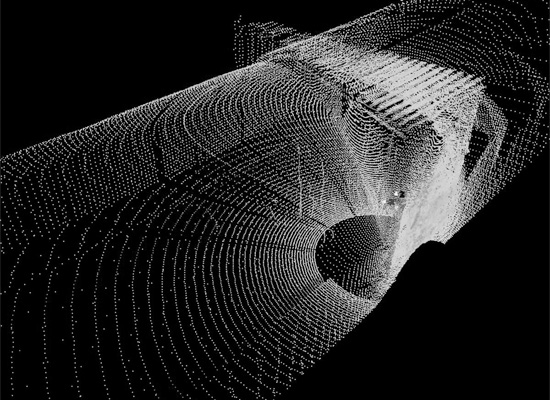
For the past 3 years, a team of archaeologists, architects and computer scientists have been laserscanning the underground network of burial chambers, tunnels and chapels carved out of the soft, volcanic tufa rock of Lazio.
The scanner, according to BBC News, “looks like a cylinder on a tripod, stands a metre or so high and is a piece of kit you usually find in the construction industry.”
Gone are the days when archaeologists just used shovels, brushes and sieves to unearth the past.
The scanner has been placed in hundreds of different locations in the Catacombs.
It turns slowly, sending out millions of light pulses that bounce off every surface they come into contact with. The light pulses rebound back into the scanner and are recorded on a computer as a series of white dots, known as a "point cloud".
Gradually, every wall, ceiling, and floor is bombarded with the dots, enabling the computer to build up a picture of each room.
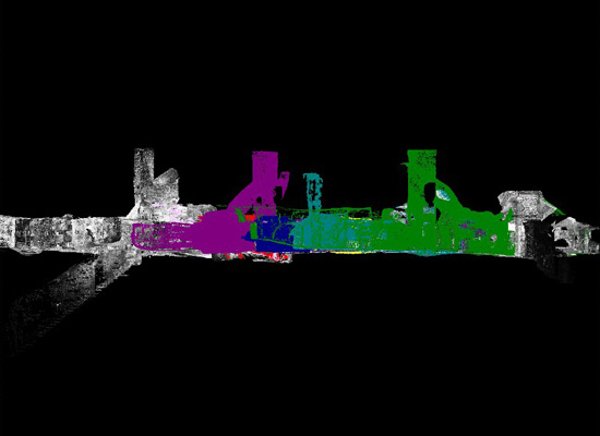
All told, “four billion dots” were gathered, and on a computer screen, they coalesce into a digital 3D model of the necropolis: a filigreed network of subterranean voids that's not unlike the complex clustering of a Romanesque basilica and its companion buildings.
You can zoom in and zoom out, rotate about the axis, and render it with color. Perhaps you can record your scopic drive through this digitized world, as one would with Google Earth. Give it a soundtrack, and you've got yourself a YouTube music video.
And maybe Radiohead would like to give it a go for a sequel to House of Cards.
One of the stated goals of the project is to study the paintings in the Domitilla catacombs: from the pagan images of the early 3rd century to the theologically fully developed Christian iconography of the late 4th century, and how this micro-history of early Christian art reflected the broader changes in late Roman society.
Now if only someone could make the laserscanner mobile (a spelunking Paranoid Android) and then send it roving through other labyrinths — other necropolises, ancient underground aqueducts, sewers, stormwater megatunnels, abandoned subway tunnels — kicking up an underground maelstrom of point clouds.
Google comes a-knockin', and soon everyone will be exploring these passages in a flurry of nighttime clicks. Google Hadesview®.
1) Choose from any of these hyper-surveilled storage reservoirs in the Pacific Northwest.
2) Excavate “teacup” basins in a plaza. Downscale their dimensions in proportion to the reservoirs selected in (1) so they will all fit within the installation site.
3) Ring the basin interior with concentric steps-cum-seats.
4) Hack into the servers of the U.S. Department of the Interior where the data on water levels at the reservoirs is collected and parsed. (Or does the bureau have an API?)
5) Re-network the flow of data from these real-world reservoirs, so that not only will the numbers get rendered into info-porn, they will also determine the water levels of your simulant reservoirs.
While writing our earlier post on Rome, we remembered that the city is pockmarked with stone markers accurately recording the dates and high water marks of historic flood events. Most are embedded on the sides of buildings, and their inscriptions read something like this:
ANNO DOMINI MCDXXII IN DIE SANCTI ANDREE CREVIT AQUA TIBERIS USQUE AD SUMITATEM ISTIUS LAPIDIS TEMPORE DOMINI MARTINI PAPE V ANNO VI.
Or:
In the year of the Lord 1422 on the day of Saint Andrew the water of the Tiber rose as far as to top of this stone, in the time of Pope Martin V, his sixth year.
In many markers, a finger, from which a swirl of lovely, frothy curlicues swooshes out, points instead to the upper limit of inundation.
According to Aquae Urbis Romae, “nearly one hundred flood markers still exist,” with the earliest dating to the 13th century. None from earlier eras are extant, but presumably there were many, a collective testament to a watery past.
When it wasn't being ravaged by veritable dry disasters such as barbarian invasions, plagues and fires, Rome drowned.
Here's an educational video from Japan's Ministry of Agriculture, Forestry and Fisheries. It's remarkable for making very complex, interconnected issues — i.e., food security, public health, global trade, energy and geography — more readily understandable. And in under 5 minutes! Quite an amazing feat.
It's rather reminiscent of the ephemeral films made by government agencies and corporations of 1950s America. The production quality here is more slick, but it's still propaganda, a brand of social engineering instilling institutional definitions of patriotism and good citizenship. Good Japanese eat Japanese food.
Cultural hegemony via pastel colors and infographics porn.
Research into Lou Gehrig's disease has demonstrated that, at least in mice carrying the associated genetic mutation, this neurodegenerative disorder can spatially manifest itself as “very subtle” but detectable behavioral patterns before the onset of symptoms.
Quoting at length a press release from the American Psychological Association:
Researchers led by Neri Kafkafi, PhD, of the Maryland Psychiatric Research Center, part of the University of Maryland's School of Medicine, mathematically analyzed about 50,000 predetermined movement patterns that resulted when rats roamed freely, one by one, in a small arena. The software created an abstract space defined by combinations of behavior such as speed, acceleration and direction of movement. Mining the resulting behavioral data enabled researchers to test many more facets of behavior than they could analyze manually.
After videotaping the movement of two groups of rats – one type with the mutation that results in an ALS-type syndrome, the other type normal controls — the scientists used the computer to "pan" for differences between groups and identified a unique motor pattern in mutant rats two months before disease onset (which would equate to roughly five to 10 years in humans).
Of the multitude of behavior patterns analyzed, the predefined "heavily braking while slightly turning away from the wall" showed a group difference. In two independent data sets, rats with the ALS-type mutation were significantly less likely than controls to brake and turn from the arena wall as they approached.
The benefit of this study is that “by being able to predict more accurately which carriers may express the disease before they experience symptoms (the 'premorbid' state), researchers could test medicines that might prevent symptoms from emerging.”
One wonders whether this sort of research, somewhere down the line, will result in public places getting littered with CCTV cameras data mining for the tell-tale signs of genetic diseases affecting motor functions. Similarly when traffic cameras take a photo of your license plate when you go over the speed limit and then get your ticket in the mail a couple of days later, these outdoor medical scanners take a photo of your face, match it up to a database at the CDC and a couple of days later, you get a diagnosis in the mail.
There will be a specially outfitted plaza where those without health insurance can get their free check-ups. Those with no more sick days can simply walk pass through on their way to work or linger about during their lunch breaks. Hypochondriacs will come in droves and stay there, like skateboarders to a Brutalist plaza.
If there is a predictive behavioral pattern to a pedophile's movements within the spatial confines of playgrounds and parks (that is, if children still go outdoors anymore) as well as the streets bordering schools, you get a court order to receive some psychiatric counseling.
Do terrorists have a genetic mutation that not only affect their cognitive reasoning but also their motor functions, the pattern array of which is so perceptibly different with that of non-terrorists that you can “spot” them?
Below are some screen captures taken from animations of cross-bedding formation that you can download from the U.S. Geological Survey.
The sinuous patterns that you see on the sides of these modeled landscape correspond to actual stratigraphic markings in the real world — earth's own hieroglyphs that can be read and interpreted, allowing one to piece together a narrative of events from deep time.
Similar images appeared here quite awhile back, then in monochrome. Having recently been reacquainted with them, we thought it would be fun to post another series, now in sepia.
And we also thought it would be fun to imagine a new urban public space inspired by these animations.
It's Chicago's Federal Plaza — that “space in between” three black boxes by Mies van der Rohe in the Loop — turned into a giant version of Janis Pönisch's Dynamic Terrain. Into an undulating patch of the urban grid.
Uploaded into this terrestrial machine would be all the data accumulated by the USGS on cross-bedding. Flip the switch and ancient worlds get resurrected, forming and deforming once more for all to see. During the morning hours, extinct sand dunes come alive, and in the afternoon, Jurassic riverbeds get their chance to distort and convulse in a forest of Miesian lines.
And all the while, office workers enjoy their lunchtime break undisturbed; tourists listen in to a lecture on Chicago architecture in a valley temporarily sheltered from the surrounding tectonic upheavals; and the homeless get comforted by the mesmerizing rhythms of this amorphous surface.
Until, of course, some unfamiliar wave patterns begin to rattle the whole place. The USGS has detected a 9.0 earthquake somewhere in the world, and since its servers are networked to the plaza, this potentially catastrophic event gets replicated in Chicago in real-time. Everyone who was there — who was tempest tossed by telepresent seismic waves, bruised but not battered — gets interviewed by CNN.
Or maybe it's been hacked, because someone has a grievance with the government. The plaza has always been the site of political protest; after its renovation, however, organizing large crowds has been difficult. But as proven by these hackers, it can still process acts of civil disobedience.
We are forced to face the reality on a daily basis that environmental damage is more advanced than experts predicted. As global warming becomes the top of almost every government’s agenda, recent trends have put pressure on world leaders to act immediately: for instance, forced recycling, carbon offsetting and a 10-year campaign to make environmentally friendly living fashionable.
Nitta then asks:
Are these efforts really improving the environment? Are these activities saving the Earth?
Considering that her “project takes current green trends to the extreme,” Nitta's answer seems to be that our current efforts are not making a dent, hence the Animal Messaging Service.
The A.M.S. is an alternative form of communication whereby so-called extreme green guerrillas “send messages internationally by hacking into the animal migration system.” The environmental benefit of this is that it doesn't tie you to big corporations, as one would be if using the Internet and mobile phones, and unlike conventional postal systems, it doesn't leave a huge carbon footprint.
But how does it work?
As but one of Nitta's scenarios, animated here in this flash animation for the Institute of Contemporary Arts, London, an EGG member relays his favorite recipe from London to New York by first hacking it into an RFID-tagged whooping swans as they pass through in April during their annual migration. These swans would then fly off, stopping along the way in Iceland. There, unbeknownst to them, the recipe would be hurriedly extracted, either automatically or with further hacking by camouflaged EGG members, who then waits for polar bears to transfer the electronic package into their embedded RFIDs. Amazingly, these bears can swim from ocean-locked Iceland to Greenland, where once again the recipe has to change hands, so to speak. “What is this recipe for?” we have to ask at this point; with this much effort put into getting it from one place to another, it must be for something spectacular. Well, whatever it is for, the last leg of its journey to New York will be undertaken by RFID-tagged salmons. Salmons? Hmm.
In any case, there is also a local version of this service using RFID-tagged pets and visitor animals.
One wonders if instead of hacking into an inorganic apparatus, you actually hack into the animal's biological systems. Instead of uploading the data into an RFID, the sender imprints the message into the animal's behavior, so that rather than downloading electronic bits of information, the receiver decodes the recipe from the subtle wiggling of salmons as they head upstream. To find out how much organic and locally grown basil in the solar roasted Piguail, a very close reading of the landscape is needed. Did that tail fluster or did it flutter? You'll need to brush up on hermeneutics.
You head out to Central Park to read an endearing note from your pen pal across the oceans through the murmurings of millions of starlings. Bird watching will never be the same.
The next day, you take the few flights of stairs to your rooftop garden or your neighbor's to watch honeybees waggle dance the time and place of your best friend's birthday party.
Of course, without RFIDs, one would need to provide a mechanism in which the information can jump between species. This again could be done by hacking each conscripted carrier, either genetically or behaviorally or both, to enable direct interspecies communication. For instance, a love letter translated into a humpback whale's song that starlings can understand and then transliterated into elaborate aerial maneuvers.
There might be a chance that the love letter gets garbled along the way into a message of hate, in which case, that is the price you pay for really saving the planet.
But as always, our overriding interest here would be the effects of an Animal Messaging Service on the built environment.
What if everyone, to the ultimately surprise of Michiko Nitta, fully subscribes to her vision of the extreme green lifestyle and cities everywhere adopt the A.M.S. as the default mode of communication? What then would the physical form of the city be like if its networked infrastructure is based primarily on zoology?
Is this where “vegi.tecture” reaches its true potential?
And how does one site these “natural sanctuaries” as data ports into the spatial grid? Are we going to look back again to Frederick Law Olmsted's Emerald Necklaces for our model?
Or could there be a new landscape paradigm, one that is formed and informed by aberrant interspecies interaction; the threat of Avian flu; increasingly depleted natural resources; climate change; and the growing possibility that geoengineering may just be our best chance to counteract global warming?
For answers to those questions, you will most assuredly not find any in this article, but you will read about some interesting facts about a massive government-sponsored faunal surveillance system designed to track the food supply of the U.S. by tagging livestock, poultry and other animals with RFID.
We love the illustrations The New York Times creates to accompany some of their articles. Oftentimes they are infographically dense without being cluttered, readily comprehensible without being too compromisingly simplistic, visually gorgeous without being unnecessarily flashy. For someone commonly tasked to distill fantastically complex information for laymen clients who might consider interpreting plans and schematic diagrams akin to deciphering ancient, dead languages, these illustrations always provide important lessons for creating a successful graphic presentation. There is much to learn (or emulate).
We're huge fans, in other words, collecting them ravenously as though we were lunatic orchidophiles or fanatic philatelists, and hoping all the while that they will be collated and published in a volume, which will be ten times better than anything Edward Tufte puts out, of course, though perhaps similarly overpriced, in which case, if you have your own collection, you should now create a Flickr set for it, such as the one we have recently created.
You'll find there, among others, the following graphic summarizing the U.S. Supreme Court decision on Rapanos v. United States, a dizzyingly complex case (to us, at least) rendered penetrable.
And also this more recent graphic listing five proposals to combat global warming on a gargantuan scale, all neatly and beautifully presented in 800x1155 pixels. It makes you feel as though you no longer need to read New Scientist for further research, although we wouldn't recommend you stop reading the venerable periodical.
One more? How about this on the migrating barrier islands of North Carolina?
Quite clinical and somber in its presentation of the data, and yet it's always a source of endless hilarity here on Pruned. Can you spot the hilarity?
We absolutely love the music video you did for Röyksopp's single Remind Me. It's brilliant, to say the least. And to say that we've seen it on YouTube dozens of times and then many times more afterwards would not be an exaggeration.
We also love the commercial you guys made for the French energy conglomerate Areva. We're not huge fans of nuclear power plants, but watching how uranium mined in Canada ends up lighting a dance floor somewhere in China via maps, graphs, isometric projections, sectional cut-outs, flowcharts and systems diagrams — all to the groovy disco beats of Funkytown — really made us want to buy shares in the company.
Have you seen the parody that someone made of the ad, by the way? If not, you guys should really check it out. It's hilarious.
Funnily enough all three videos remind us of our childhood — those groggy Saturday mornings waiting to see if ABC might again broadcast Conjunction Junction or any of the number of Schoolhouse Rock! cartoons showing us how the various parts of our bodies work; and those halcyon after-school afternoons watching Mister Rogers tour a factory and learn how familiar items like crayons, stuffed animals, spoons, and zippers get mass produced in a sort of mesmerizing Fordist ballet.
But we're not writing this open letter to tell you guys all about our television staple when we were 28 8 years old, rather to find out — if and when Torbjørn and Svein commission another music video — if maybe you wouldn't mind animating the mindbogglingly complex, insanely fascinating, intellectually stimulating, utterly hypnotic process of municipal wastewater treatment.
About 20 seconds in Remind Me were devoted to it, but we think it deserves a longer treatment, if not a full cinematic homage to the diagram. Don't you agree?
No doubt you are quite familiar with what goes on, but for the unenlightened, here are the search results from Google Images for “wastewater treatment” and “sewage treatment”. Additionally, this Wikipedia entry gives a nice introduction, although some parts might be confusingly too detailed.
Most people don't know much about what goes on at the treatment plant. For one thing, they are generally zoned out to the urban periphery. The more segregated they are from the populace, the better. The more they get unnoticed visually, aurally and olfactorily — again, the better. And yet sewers practically underpin modern civilization. Without them, it would be hard to imagine how megalopolises like New York City could have come into existence and then thrived. Their importance is such that people should sacrifice a virgin every year among the filtration towers, aeration tanks and Daphnias. Or to absolutely ensure that no empires and nations will crumble: two virgins.
Oh, sure, our readers will remind us that Chicago has a recycling facility located right next to the city's most popular tourist destination and in the shadow of Oprah Winfrey's palatial condo, but it's so unassuming, so pedestrian that it hardly draws much attention to itself. New Haven, Connecticut had the right idea when they asked Stephen Holl to design their facility. So many people wrote about it, most recently in Wired. Herbert Mushcamp wrote about it in the New York Times way back in 2001, calling it “poetically expressive”, but on Michael Van Valkenburgh, Holl's co-designer, he judged him to be “a splashy form maker but not a sophisticated thinker.” Ouch! Muschamp was probably right, but we've always wondered whether Nicolai Ouroussoff inherited his philistine indifference towards landscape architecture from his predecessor.
We're sure you don't give a fuck about Nicolai or his myopic architectural reportage, but we can't remember the last time people's shit (as a spatial concern) got this level of coverage. Ideally, the process alone should generate mass enthusiasm, but it seems celebrities need to be involved to stir interest. And even then that kind of attention is always fleeting.
And another thing, a lot of people have yet to fully grasp the often monumental task of channeling our shit from anywhere in the city all the way to these treatment plants, something that always boggles our mind. Sewers are understandably hidden. There's the issue of public health, for one, and there's also the matter of property values — Not In My Backyard, that sort of thing.
But apart from manhole covers and storm drains and maybe a bump in the road where a pipe got too close to the asphalt, there isn't a lot of surface evidence. They're everywhere, rhizomatically entrenched, and yet only when a main sewer line gets clogged and stinks up the neighborhood or when there's an outbreak of cholera or when some photogenic kid falls in and an entire nation becomes hysterical, engrossed by the endless media coverage of the heroic rescue, does this all-pervasive subterranean landscape momentarily reveal itself to us, and we wonder then where our shit actually ends up. But such contemplation should be performed on a daily basis.
So this is where you guys come in. An H5 music video (avant-doc?) will certainly get copious amount of airplay on MTV2, even if it's about sewage. Your style is eye-popping, though definitely not intellectually vacuous; it is so hyper-slick that it will inject some glamour to an otherwise unglamorous subject. Predictably, someone will upload it to YouTube, where millions will watch it. Many more will embed it on their blogs or use it to further disfigure their MySpace pages. Bored interns will e-mail it to everyone. It'll be the new viral video, ingeniously parodied endlessly by yet more bored interns. One such parody on the near nonexistent wastewater treatment of Mumbai will appear on VH1's Best Week Ever, E!'s The Soup, Bravo's Outrageous and Contagious Viral Videos, and several other pop cultural affairs programs.
And then joy upon joy, the appalling state of ignorance and popular apathy towards wastewater treatment is reversed.


