Showing posts with label infrastructure. Show all posts
Showing posts with label infrastructure. Show all posts
Interstate Gramophone
For this ad of the 2009 Honda Civic, a stretch of highway has been engraved with a specially sequenced sets of rumble strips. When a car drives through, the wheels and car body vibrate a distinctive musical tune. In this case, it's the William Tell Overture that soundtracks the passing landscape.
It goes without saying that longer pieces are needed. Imagine driving through the unrelenting vastness of the American West, and all of a sudden, your car begins to shudder an entire Aaron Copland score. This will surely gladden your heart and fluff up your patriotic spirit. Or equally likely, trigger a prolonged bout of road rage, in which case more than 30 seconds worth of jingle is probably not such a good idea.
Under the city, under the streets where you walk, that’s where we dive

Our Future Plural partner site, Edible Geography, has posted the transcript of the talk given by one of their invited speakers at Postopolis! DF: Julio Cou Cámara, a sewer diver for Mexico City.
Cámara might seem like a strange choice, but as Nichola Twilley succinctly explains, “the infrastructure of waste disposal is the (frequently invisible) corollary of consumption.” For every input, there's an output.
Here's an excerpt:
People are always wondering why there’s so much flooding in the city. I can tell you that the city floods because of all the rubbish that creates blockages in our drainage system. If we were maybe a bit more conscious about rubbish and we didn’t throw it on the street, we wouldn’t have this many flooding problems in the city. People complain—they say, “There’s almost a lake in the street.” Well, yeah—that lake is there because of your rubbish.
The drainage system is constantly being maintained—all year long, twenty-four hours a day, there are people working. They need a diver when they can’t stop the pumping plant, because if they stopped it, the city would be flooded. That’s when they ask for my help. We go there and we see what the problem is and we do the job.
We work blindly in the black water. It contains animal poo, human poo, hospital waste... any kind of pollution you can think of. All of that is in the sewage water. That’s where we work. Right now there are only two of us diving for Mexico City.
Go read the rest of Cámara's presentation, plus the Q&A afterwards.
The Return of the Sewer Divers
Disaster Tumuli

Inscribed on that liminal space where civilization messily interfaces with the wilderness is a series of monumental earthworks protecting the Icelandic town of Siglufjörður from snow avalanches and landslides.
While the planning and construction of these defense structures were the work of a multi-disciplanary team, for our own purposes, we'll concentrate on the contributions of the landscape architects involved in the project, specifically the Reykjavík-based firm of Landslag.


These anti-disaster tumuli were built in two phases. Completed in 1999, Phase I involved the construction of two deflecting dams on the south end of town. These direct avalanches from the most hazardous locations away from the populated area. The smaller of these dams, at 200m long and 15-16m high, is not as visible as the larger dam, which measures 700m long and 18m high and runs prominently up along the mountainside to an elevation of 180m.
Completed in 2008, Phase II involved the construction of 6 walls and dikes running along the entire mountainward side of Siglufjörður. Unlike the two deflecting dams built in Phase 1, these are intended to stop the flow of an avalanche rather than change its course.

During the early planning stages of the project, there were concerns about the negative social and even psychological impact of these massive landscape alterations on the town's residents, who, despite acknowledging their vital role in preventing fatalities and property damage, might nevertheless show strong resistance to such large-scale structures. This is where Landslag came in.
Working closely with the engineers, geophysicists and meteorologists, Landslag focused on minimizing the visual impact of the project. Their solution was to approach the structures not only as fortifications against nature but also as an opportunity to create recreational spaces out of the defensive infrastructure. They were turned into an architectural statement, a positive cultural asset rather than an invasive structure. Since these gigantic structures could never be hidden, nor could they be camouflaged from view with tall-growing trees, turning them into landmarks was very logical.

The avalanche defense structure, in fact, doubles as an outdoor recreational facility. Paths weave around the structures and run on top along their ridge lines, directing hikers up the mountain. Already these trails are heavily used. At the end of the larger deflecting dam is a sloping bastion used as a public viewing platform. It's a hazard zone, but they're also occupiable.


In order to avoid the deflecting walls from looking too dominating, they were designed to mimic the natural features of the surrounding landscapes. With the additional use of natural materials, their organic, undulating forms help to blend them into the landscape. To even further soften their substantial profiles, a process has been started which in decades to come will see the natural vegetation of the area reclaim and inhabit it once again.

It is worth contrasting these with the avalanche protection structures at Drangagil Neskaupstaður and Flateyri, which look like they belong more to a Medieval walled city.
Gazex®
Wearable Anti-Avalanche Homes
Sites of Managed Anxiety
Support Akvo
Akvo (from the Esperanto word meaning “water”) is a non-profit foundation committed to bringing low-cost, sustainable water and sanitation technology and approaches to local communities. It's sort of like Open Architecture Network but with a more focused infrastructural concern.
In the same vein as OAN's open source ethos, Akvo maintains a wiki, naturally called Akvowiki. It's goal is “to improve water and sanitation projects through knowledge exchange on smart and affordable technical solutions and effective approaches.”
Additionally, Akvo helps projects get funding through partner organizations and through crowdfunding.

Go fund a project now!
In the same vein as OAN's open source ethos, Akvo maintains a wiki, naturally called Akvowiki. It's goal is “to improve water and sanitation projects through knowledge exchange on smart and affordable technical solutions and effective approaches.”
Additionally, Akvo helps projects get funding through partner organizations and through crowdfunding.
Go fund a project now!
Mapping Abysses
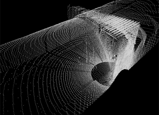
While clearing several months' worth of accumulated bookmarks, we rediscovered an article from The New York Times about laser scanning in Glasgow — or to be more precise: laser scanning the city itself.
A few years ago, we read, a group from the Glasgow School of Art “began surveying a swath of the center of Glasgow, along the River Clyde, creating 3-D digital representations of some 1,400 buildings and dozens of streetscapes.” The project led to commissions from the Scottish government's heritage agency to scan other historical landmarks in the country. And later this spring, the group will be part of a team that will scan Mount Rushmore to create “the most complete and precise three-dimensional models ever of the site, millions of times more detailed and accurate than the best photographs or films, precise down to the tiniest fraction of a millimeter.”
So precise are these digital models that they can be used not only to facilitate much needed restoration work of deteriorating monuments but also to recreate them if they are completely destroyed by natural or man-made disasters. In other words, if the Bamiyan Buddhas had been laser scanned before they were obliterated by the Taliban, they could now be reconstructed with unbelievable accuracy.


We're inevitably led to fantasize a team of laser scanners shooting billions of pinpricks of light at the Acropolis or Machu Picchu, converting them into deterrestrialized point clouds. Not waiting until the buildings get corroded down to bedrock by an abrasive mixture of tourists and climate change, or even until the scans are completed to start reconstruction, the surveyors connect their data servers to a distant swarm of Pike Loop robots, which immediately begins to fabricate these ancient sites in foreign terrain. It's BLDGBLOG's wettest wet dreams.
Better yet, forget those surface monuments. How about something subterranean like the underground necropolis of Domitilla outside Rome or La Subterranea in Guanajuato, Mexico? Both of these places have been laser scanned, and their ghostly digital facsimiles await to be physicalized.

There are also those abandoned sewers, stormwater tunnels and subway tunnels. Day and night, laser scanners that have gone mobile will be deployed into these voids, and bit by pinprick bit, these labyrinths that once confounded, concealed and even consumed trespassers with their disorienting mazes will resolve into total comprehensibility. Every detail will be known to you.
Simultaneously, disembodied limbs out in some vast tract of land will get to work replicating these filigreed abysses. Once completed, it will look like a city eroded down to its subsurface infrastructure. It'll be the playground for urban explorers who might be looking for more muted thrills and for architects who could no longer wait for the mythical Golden Age of WPA 2.0 to play out their desires.
CLUI and Atlas Obscura will no doubt lead tactical tours.
What will you do here in this infrastructure disconnected from the network?
Waterpleinen

To launch its 14th anthology, Water, Alphabet City has organized a series of events this week in Toronto, two of which are the HYDROCity symposium and its accompanying exhibition at the University of Toronto. Another event is a lunchtime talk in which Jeroen Bodewits will discuss Waterpleinen, a project designed by Florian Boer and Marco Vermeulen to reconfigure the stormwater infrastructure of Rotterdam.
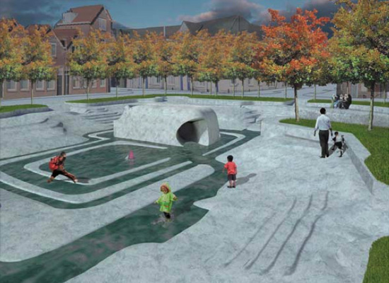
In Florian Boer and Marco Vermeulen's proposal, rainwater runoff isn't funneled into a complex system of underground pipes, a system that is rather expensive to build and maintain, but is managed instead through a network of surface reservoirs, the Waterpleinen, or Watersquares. These storage spaces will be dry for most of the year, but during storm events, they will collect water from the surrounding neighborhood. If one reaches capacity, excess water will overflow into another basin. After the rain, the collected water will slowly recede into nearby bodies of water or seep into the soil.
So instead of being buried in concrete, excised from the daily life of the city and only experienced by municipal workers, urban hydrology is visibly, even prominently, incorporated into the surface fabric of the city. Programmed with recreational opportunities when its dry and even while inundated, its infrastructure provides active public spaces for the local area, not dark playgrounds for a handful of urban explorers. It even becomes an event, its frolicking rivulets and interior lakes staged for the young and old.
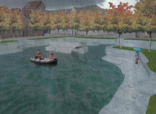
Originally developed in 2005, this concept has since become official urban policy. At least 25 watersquares are planned for Rotterdam in the coming years, with a prototype to be constructed soon.
Hyperlocalizing Hydrology in the Post-Industrial Urban Landscape
Hydrocity: Call for Projects

On November 6, 2009 at the University of Toronto, InfraNet Lab, in collaboration with Alphabet City, will oversee a daylong symposium and launch an accompanying exhibition that will travel throughout North America. Called Hydrocity, they will be “devoted to studying the relationship between urban forms and the hydrological systems in which they are embedded.”
If the twentieth century has been marked by our global thirst for fuel, the twenty-first century, will be defined by our collectively growing need for water. Impending water shortages are changing patterns of urbanization and requiring increasingly elaborate infrastructures by which to source, collect, divert and transport water to the urban centres that hold a growing majority of the world’s population. These population centres will in turn need to be redesigned and retrofitted to conserve, collect, repurify, and recirculate increasingly precious water resources while at the same time rethinking and rebuilding their cities’ relationships with the complex watersheds on which they are built and upon which they depend. The resulting liquid infrastructure is poised to redefine our notion of natural and artificial landscapes, as disparate ecological environments are networked and conflated. What forms of urbanism and landscape systems will emerge, and what design potentials exist, in this expanding liquid infrastructure?
Participants in the symposium include such top-notch hydrospatialists as Alan Berger, of P-REX; Katherine Rinne, of Aquae Urbis Romae; and Aziza Chaouni and Liat Margolis, who have also organized a traveling exhibition with a similar theme, The Out of Water Project.
As for the exhibition, some projects have already been selected, but InfraNet Lab is very keen to include other visionary projects — “built, unbuilt, dreamed, etched, scripted, carpet-bombed, etc.” — that address the same issues, preferably recent and unpublished.
To be considered, send a PDF (3 pages or less and under 6MB) of any project by October 15 to editors[at]infranetlab[dot]org. Space is limited, so earlier submission is preferred.
Send tips if you haven't a project of your own. We've suggested Watery Voids by MMBB Arquitectos and SpongeCity, which was designed by former students at Harvard Graduate School of Design.
Egg Digesters
We've set up a new Flickr set and stuffed it with photos of egg-shaped sludge digesters culled from the web, simply because they're absolutely beautiful. They're readily photogenic — with or without dramatic lighting.
In the sewage treatment process, these extraordinary womb-like structures break down the organic solid matter in the wastewater into more stable materials. With additional processing, some of these byproducts are turned into fertilizers. These digesters also generate biogas with a high proportion of methane that can used to power the machines. In fact, in large treatment plants, they can produce more electricity than the installations require. The egg shape makes this process more efficient. Compared to their more conventional cylindrical counterparts, they require less energy, maintenance and space. That they are aesthetically pleasing is probably just a happy coincidence.
They're clearly calling out for a book deal, so it's worth asking again if they've ever been the subject of a 1,000-pound coffee table book published, say, by the interior decorator Taschen.
Or have they perhaps been the object of interest in a typological study by a special-interest niche publisher and released as a slim print-on-demand pamphlet?

Are the next Bernd and Hilla Becher out there now documenting these industrial Fabergés?
Grain Elevators
Buttology 2
Buttology 2
Here now is the fantasy table of contents for the fantasy second issue of Buttology, a fantazine for the spatial study of waste.
Examining The Waste Stream
“Garbage is the effluent of our consumption, and it flows backwards through the landscape of Los Angeles. Unlike liquid wastes, which drain downslope to the sea, the tiny tributaries of trash, from millions of homesteads, collected by a fleet of thousands of trucks circulating in constant motion, hauling to nodes of sorting, distribution, reuse, and, finally disposal, flow up the canyons and crevices to the edge of the basin.”

No Island is an Island
Mining and exporting its rich deposits of phosphates, formed from bird shit deposited over thousands of years, the tiny Pacific island nation of Nauru had for a time the highest GDP per capita. But with the depletion of its major natural resource and the mismanagement of the trust fund set up to provide for its post-phosphate future, the country now has one of the lowest. It wasted away its island in return for not much.
To keep its economy afloat, it allowed the creation of secret offshore banks. Some of these banks' headquarters are no more than shacks, but through one of these shacks in 1998, “Russian criminals laundered about $70 billion, draining off precious hard currency and crippling the former superpower.”
In 2001 until 2007, Nauru agreed to settle Afghan and Iraqi refugees fleeing the Taliban and Saddam Hussein and seeking asylum from Australia. With the millions of dollars in aid the government received in return, one would have expected decent accommodations for them, but living conditions were not much better than those at Guantanamo.
And then there was that deal it made with the United States to set up safe houses in China for North Korean defectors.

Growing Water
Runner-up in the Pamphlet Architecture #30 competition, and currently on view in the Burnam Plan Centennial exhibition Big. Bold. Visionary. Chicago Considers the Next Century (where it's one of a very, very, very few handful of projects that actually fit those three modifiers) is UrbanLab's proposal for an alternative wastewater treatment system for Chicago.
Frog's Dream
“[T]he Frog’s Dream project attempts to re-establish a sustainable relationship between city and suburbia. It proposes to transform the vacant McMansions, at the periphery of cities, into eco-water treatment machines, commercially known as Living Machines, in which a micro-ecosystem of plants, algae, bacteria, fish and clams are present to purify the water. A micro-wetland ecosystem will be formed around these mansions to sustain larger wetland animals and plants. The project also involves transforming the highway system into a multi-functional infrastructure that transports cars, trains and bikes, as well as forming a network to facilitate water transport between a city and its surrounding suburban wetlands.”
puRE
“The peri-urban Revitalization Element [puRE] is a catalyst for fostering sustainable development within existing suburban areas, by re-envisioning a classic suburban icon—the swimming pool—and transforming it into a productive, water-treating element within a community.”

Q&A with Rose George
Rose George is the author of The Big Necessity: The Unmentionable World of Human Waste and Why It Matters. Last month in The New York Times, she answered questions sent in by readers about toilets, sewage and other topics about waste disposal in New York City. Here's a sample:
Q: Are there any ways to use the large amount of human waste generated by New York City for the common good, like turning it into drinking water or compost, for example, that would not require a huge financial commitment or a significant change in infrastructure?
A: Human waste is such a misnomer. It is an extremely useful product. As you point out, it can make biogas, for a start. In China, 18 million or so households get their cooking fuel by linking their latrine to a biogas digester (an airtight underground tank), tapping off the methane and cooking with it. It cuts down on deforestation and is cheap and infinite. There is really interesting stuff going on in Europe, too, where Lille in France, Stockholm in Sweden and a few other cities are running buses and taxis on biogas produced from sewage and household garbage.
In fact, the only waste about human waste is that it goes to waste; even in the 19th century, Karl Marx calculated that London was losing a fortune by throwing all that potential fertilizer away into its water system.
But back to biodiesel: Yes, there are companies working on that, including one in Canada which you can find if you search online for “biodiesel” and “human waste.” The trouble with sewage as an energy source is that the technology for now — even though it’s ancient (Marco Polo reported seeing biogas tanks in China in the 13th century) — it’s not yet cost-effective. Some wastewater treatment plants get gas or electricity from the process, but by no means all. It is often seen as prohibitively expensive, especially when the plants are struggling to run and meet all sorts of regulations.
Money is going into the wastewater infrastructure from the federal stimulus bill, which is great, but I would like to see more of it dedicated to exploiting this chronically and acutely undertapped source of energy. It will cost money, but so did putting in the infrastructure in the first place, and it will probably pay its own way eventually. It’s definitely a chronically and acutely underexploited source of energy.

Dying in the Dying-field
“Dying-places are ordinarily in homes or in hospitals, but this poor fellow has neither a home nor a hospital in which to die. We are here in a vacant space near the river—a sort of common littered with refuse and scavenged by starving dogs. It has been named the Dying-place, because poor, starving, miserable outcasts and homeless sick, homeless poor, homeless misery of every form come here to die. The world scarcely can present a more sad and depressing spectacle than this field of suicides; I say suicides, because many that come here come to voluntarily give up the struggle for existence and to die by sheer will force through a slow starvation. They may be enfeebled by lingering disease; they may be unable to find employment; they may be professional vagrants; they come from different parts of the city and sometimes from the country round about. They are friendless; they are passed unnoticed by a poor and inadequate hospital service; they become utterly discouraged and hopeless and choose to die. Their fellow natives pass and repass without noticing them or thought of bestowing aid or alms, and here it is not expected; they have passed beyond the pale of charity; it is the last ditch; they are here to die, not to receive alms.”
Tips for the next issue will be much appreciated. We're especially looking for built works, thesis projects, entries submitted to (ideas) competitions and proposals of a highly speculative nature.
Buttology 1
BUTT: A Proposal for a Zine
Under Spaces 3

This is a quick survey of sorts in three parts. The first two parts covered built projects. This last part contains two unrealized projects, one a student thesis project and the other a masterplan for a major urban revitalization program.
Published in 306090 07: Landscape within Architecture (2004) is Hans Herrmann's Public Domain and the Dispersed City, his thesis project at Clemson University. Sited at the intersection of Interstate 85 and Interstate 285, also known as the topologically knotty Moreland Interchange, in Atlanta, Georgia, this project aimed “to provide new forms of access to the space of the interchange through the introduction and incorporation of an urban park. As a device, the park is designed to bring focus and articulation to the roadway’s existing status as a public monument.”
Because this issue of 306090 is out of print and used ones are rather expensive, we'll quote a good chunk of the article, specifically the part about “organizational tactics”:
The park is arranged according to three structuring systems. One system is made up of a network of paths and event pads or surfaces that define activity zones both on and above the ground plane. The paths link event pads located throughout the park, while also carrying services that may be used to delineate individual event spaces. Power, water, and other utilities are supplemented by secondary sets of inlays (e.g., information-conveying conduits such as telephone lines, DSL, satellite feeds) that are accessed through the paths and pads. The pads and surfaces are paved, inlaid, or sometimes planted. To promote varying forms of occupation, the pads feature points of connection to the utilities supplied through the adjoining paths.
Throughout the course of a year, the paths and pads are opened and closed by a second structuring system: a carefully maintained program of plantings. The continual redefinition of space by shifting vegetation ensures a constant revitalization of the park as new venues and points of interest become available and familiar ones are closed off. In doing so, the park becomes a barometer of sorts through which the seasonal events and traditions of the city may be observed.
Given that the space of the interchange is largely conditioned by the daily cycle of traffic, time becomes the third structuring system. As conceived, the park has two temporal modes. The first is a twenty-four-hour park, comprised of the indeterminate spaces and events supported by the paths and pads, as well as the everyday points of operation such as service stations and welcome centers. The second mode is a carefully defined and choreographed set of events and venues that operate on a pre-determined timetable. That schedule is governed by a calendar of events decided upon by the city and its parks and recreation council. Those systems will function simultaneously to allow for overlaps of use and occurrence to take place while within the space of the interchange and the city at large.
As a civic construct, the proposed park supplements the interchange by supplying it with new opportunities for access. Functioning in many different ways to serve the public, the park and interchange attempt to bring dialogue to, and between, the occupants of both spaces, while fostering a dynamic layering of activities and interactions.


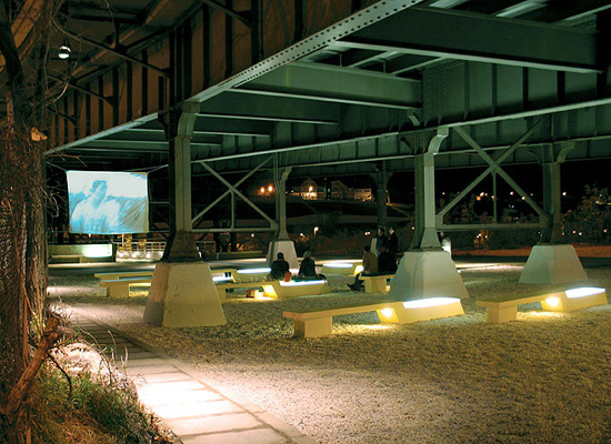
The East River Waterfront Esplanade and Piers is a planned series of public spaces below and in the vicinity of F.D.R. Drive, an elevated highway on the eastern edge of Lower Manhattan.
The masterplan was developed by multidisciplinary teams that included Ken Smith Landscape Architect, SHoP Architects, several engineering firms and the planning and transportation departments of New York City. You can download it from here.


Now it's your turn to let us know in the comments (or on twitter — @pruned) what similar “reclaimed” spaces below still functioning highways, bridges and rail lines that we have missed.
Under Spaces 2

This is a quick survey of sorts in three parts. This is the second part.
Covering about 7.5 acres under Interstate 5 in Seattle, Washington, is the I-5 Colonnade Park. Weaving through this concrete forest are trails, pedestrian crossings connecting two neighborhoods, an off-leash dog park and a couple of picnic areas. A major portion of the park is a series of mountain bike skills trails constructed by the Evergreen Mountain Bike Alliance and its volunteers.
This park, together with Burnside Skatepark, pictured above, is an instructive contrast to the super-designery landscapes in the first part of this quickie survey. It suggests a way to rehabilitate these forgotten, dark urban spaces without eradicating heterogeneity and fostering exclusion, which often accompany so many regeneration projects. This park is “dirty,” not Dutch, but thrives nonetheless.
A short documentary about the mountain bike park can be viewed here.


Raumlabor's Spacesbuter is a mobile pavilion made of “an inflatable bubble-like dome that emerges from its self-contained compressor housing. The dome expands and organically adjusts to its surroundings, be it in a field, a wooded park, or below a highway overpass. The material is a sturdy, specially-designed translucent plastic, allowing the varying events taking place inside of the shelter — dance parties, lecture series, or dinner buffets — to be entirely visible from the outside and likewise the exterior environments become the events’ backdrops.
“When inflated, the dome has proportions of 65.5 feet deep, 33 feet wide and 21 feet high. The space is highly adaptable and will morph depending on the surrounding environment. It merges with its surroundings: enveloping lampposts and trees while yielding to building facades or nearby vehicles.”


Looking like a den for muggers awaiting lost pedestrians retracing one desire line after another in the hopes of finding an escape route is West 8's Carrascoplein. Located underneath railway tracks on the outskirts of Amsterdam, the park (perhaps landscaped boulevard is a more apt term), as described by Ian Bourdain, is “made up what initially appears to be little more than an artificial wooded landscape: grass and asphalt surfaces littered with cast-iron tree stumps lit up from within. At night, the latter glow and cast shadows over the concrete columns and undersides of the overhead bridges. The effect is at once calm and unsettling, at times empty and eminently ignorable (especially during the day), and at others (particularly after nightfall), ambient, moody and almost unsettling in the way that light, shadows and colour flicker across the site.”
The park may look inhospitable and barren in photographs, but Bourdain assures us that the park “has been welcomed by local pedestrians, many of whom now feel much more willing to traverse the space, as well as by those seeking an alternative urban experience – in this case, a dance of light and shadows. The risk of doing something quite strange in an out-of-the-way location has been repaid by improvements in the quality of the place and its attractiveness to people living elsewhere in Amsterdam.”


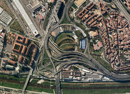
Battle i Roig's Parc Nus de la Trinitat (1993) is located in one of the most important road networks in Barcelona. With public open spaces at a premium, the designers planned out a very dense program arranged within two semicircular bands around a central circular green space. Squeezed inside include a water channel, two tennis courts, urban farm gardens, a volleyball court, a basketball court, a mini-football pitch and picnic areas. The layout no doubt echos the presence of the ring roads; nevertheless, through grade changes, landform construction and strategic plantings, the roundabout and its traffic are visually and aurally screened out. In some areas, you would hardly think that you were in the middle of “the largest system of ring roads in the city.”
(Or actually, according to this post [in Catalan; thanks, Louis Carrogis, for the translation] and the photos contained within, the park is hardly a peaceful respite. In fact, it's in a very dilapidated state. The entrance to the park, says the author, looks like an industrial zone or a big parking lot that's far from inviting. The pool is without water, and the bathrooms and courts badly need maintenance. The landscape is unsightly. Must be the recession, drought — i.e., climate change — and opportunistic squatters marginalized from other public spaces.)


To be continued.
Subscribe to:
Posts (Atom)